
Magnitude |
:2.8 |
| Date & Time (UTC) | 2016-07-22 02:44:47.2 |
| Date & Time (Local) | 1395/5/1 07:14:47.2 |
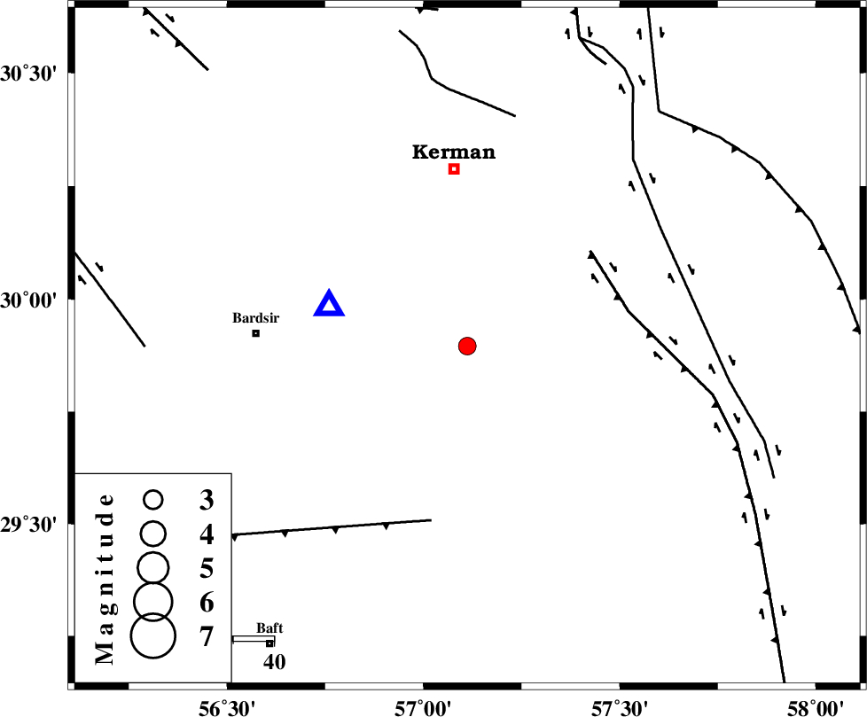
| Location | Lat:29.895 Lon: 57.112 |
| Region | Kerman Province, 44 km South of Kerman |
Nearest Cities |
|
| 17 km South of Jupar, Kerman Province | |
| 21 km South of Maheabad, Kerman Province | |
| 23 km South West of Mohiabad, Kerman Province | |
| 24 km South West of Mahan, Kerman Province | |
| 25 km South West of Langar, Kerman Province | |
| Depth | 14 km |
| Agency | |
Faults within 150 km: |
|
| GOWK_F (Length: 152 km) , Distance to epicenter: 38 km | |
| LALEHZAR_F (Length: 52 km) , Distance to epicenter: 44 km | |
| GOLBAF_SIRCH_F (Length: 114 km) , Distance to epicenter: 56 km | |
| Number of Phases | 6 |
| RMS | 0.1 |
| Number of Stations | 3 |
| Error in Latitude | >7.2 km |
| Error in Longitude | 3.5 km |
| Error in Depth | 5.3 km |
Download waveform in seisan format
to download seisan software Click here
to access information about IIEES stations Click here
Amplitude | ||||||||
| UID | Agency | Station | Component | Amplitude | Period | Arrival Time | Proccessing Time | Signal Clip |
| 107890 | IIEES | KRBR | N | 1453.3 | 0.17 | 2016-07-22 02:44:59 | 2016-07-23 05:24:00 | n |
| 107891 | IIEES | KRBR | E | 3453 | 0.13 | 2016-07-22 02:44:59 | 2016-07-23 05:24:00 | n |
| 107892 | IIEES | TABS | N | 5.6 | 0.6 | 2016-07-22 02:46:56 | 2016-07-23 05:24:00 | n |
Phase | ||||||||||||
| Agency | Station | Component | Phase Type | Phase Quality | First Motion | Observed Arrival Time | Time Residual | Loc. Flag | Input Weight | Distance | Azimuth | |
| IIEES | KRBR | Z | Pg | E | 2016-07-22 02:44:54 | -0.01 | y | 35.2 | 286 | |||
| IIEES | KRBR | N | Sg | E | 2016-07-22 02:44:59 | -0.03 | y | 35.2 | 286 | |||
| IIEES | BSRN | Z | Pn | E | 2016-07-22 02:45:32 | -0.14 | y | 300 | 39 | |||
| IIEES | BSRN | E | Sg | E | 2016-07-22 02:46:11 | -0.07 | y | 300 | 39 | |||
| IIEES | YZKH | Z | Pn | E | 2016-07-22 02:45:47 | 6.7 | n | 4 | 366 | 320 | ||
| IIEES | TABS | Z | Pn | E | 2016-07-22 02:45:46 | 0.29 | y | 416 | 0 | |||