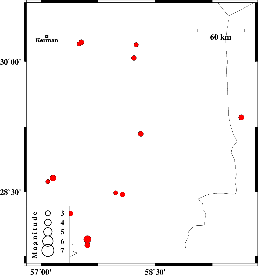
| Prel. Rep. | Date | Time(UTC) | Time(Local) | Lat. | Lon. | Depth | Mag. | Region | Waveform |
|
|
2015/05/20
|
18:44:27.8
|
23:14:27.8
| 28.25 | 57.39 | 18 |
ML:2.9
|
Kerman Province, 45 km North-West of Kahnuj | |
|
|
2015/05/20
|
01:16:29.4
|
05:46:29.4
| 29.17 | 58.31 | 14 |
ML:3.1
|
Kerman Province, 8 km Bam | |
|
|
2015/05/18
|
11:03:31.3
|
15:33:31.3
| 30.04 | 58.22 | 15 |
ML:3
|
Kerman Province, 105 km North-West of Bam | |
|
|
2015/05/15
|
00:31:41.0
|
05:01:41.0
| 28.49 | 57.98 | 15 |
ML:2.6
|
Kerman Province, 31 km South-East of Jiroft | |
|
|
2015/05/13
|
20:27:21.6
|
00:57:21.6
| 27.95 | 57.61 | 18 |
ML:4.4
|
Kerman Province, 8 km Kahnuj | |
|
|
2015/05/11
|
09:05:18.2
|
13:35:18.2
| 30.22 | 57.53 | 14 |
ML:3.1
|
Kerman Province, 44 km East of Kerman | |
|
|
2015/05/08
|
03:36:33.3
|
08:06:33.3
| 28.47 | 58.07 | 18 |
ML:3
|
Kerman Province, 39 km South-East of Jiroft | |
|
|
2015/04/29
|
01:47:36.6
|
06:17:36.6
| 27.88 | 57.61 | 14 |
ML:3.2
|
Kerman Province, 11 km Kahnuj | |
|
|
2015/04/22
|
16:00:56.9
|
20:30:56.9
| 29.36 | 59.63 | 18 |
ML:3.2
|
Sistan va Baloochestan Province, 121 km South-West of Zahedan | |
|
|
2015/04/22
|
00:34:17.2
|
05:04:17.2
| 30.2 | 57.5 | 15 |
ML:2.6
|
Kerman Province, 42 km East of Kerman | |
|
|
2015/04/21
|
02:37:34.3
|
07:07:34.3
| 28.62 | 57.09 | 17 |
ML:2.6
|
Kerman Province, 64 km West of Jiroft | |
|
|
2015/04/20
|
20:37:36.2
|
01:07:36.2
| 28.66 | 57.16 | 14 |
ML:3.6
|
Kerman Province, 57 km West of Jiroft | |
|
|
2015/04/20
|
12:12:27.9
|
16:42:27.9
| 30.19 | 58.25 | 18 |
ML:2.7
|
Kerman Province, 120 km North-West of Bam | |
