
Magnitude |
:1.9 |
| Date & Time (UTC) | 2015-06-25 12:35:18.3 |
| Date & Time (Local) | 1394/4/4 17:05:18.3 |
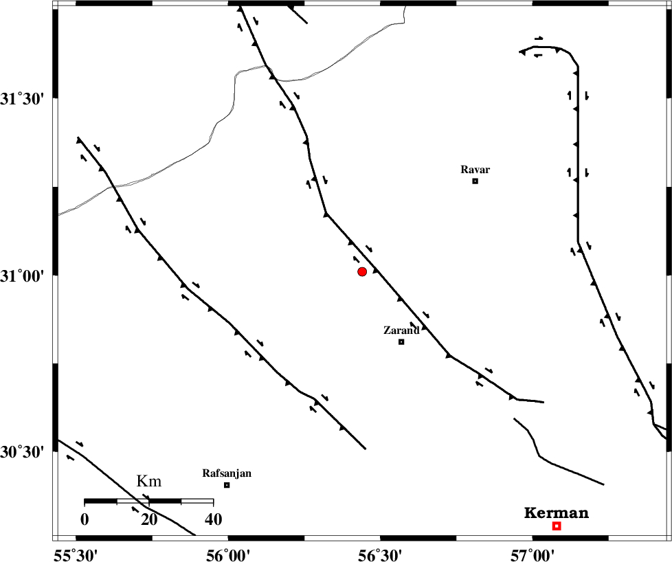
| Location | Lat:31.01 Lon: 56.44 |
| Region | Kerman Province, 25 km North-West of Zarand |
Nearest Cities |
|
| 13 km West of Dasht-e khak, Kerman Province | |
| 16 km South of Toghroljerd, Kerman Province | |
| 18 km North West of Ahmadi, Kerman Province | |
| 25 km North West of Zarand, Kerman Province | |
| 27 km North West of Mohammadabad, Kerman Province | |
| Depth | 14 km |
| Agency | |
Faults within 150 km: |
|
| KUHBANAN_F (Length: 189 km) , Distance to epicenter: 5 km | |
| DARIVAN_F (Length: 131 km) , Distance to epicenter: 41 km | |
| CHATRUD_F (Length: 37 km) , Distance to epicenter: 66 km | |
| Number of Phases | 4 |
| RMS | 0.1 |
| Number of Stations | 3 |
| Error in Latitude | >2.8 km |
| Error in Longitude | 3.5 km |
| Error in Depth | 5.6 km |
Download waveform in seisan format
to download seisan software Click here
to access information about IIEES stations Click here
Amplitude | ||||||||
| UID | Agency | Station | Component | Amplitude | Period | Arrival Time | Proccessing Time | Signal Clip |
| 96051 | IIEES | KRBR | E | 26 | 0.28 | 2015-06-25 12:35:55 | 2015-06-25 02:11:00 | n |
| 96052 | IIEES | KRBR | N | 22.7 | 0.32 | 2015-06-25 12:36:00 | 2015-06-25 02:11:00 | n |
| 96053 | IIEES | YZKH | E | 13.3 | 0.63 | 2015-06-25 12:36:29 | 2015-06-25 02:11:00 | n |
Phase | ||||||||||||
| Agency | Station | Component | Phase Type | Phase Quality | First Motion | Observed Arrival Time | Time Residual | Loc. Flag | Input Weight | Distance | Azimuth | |
| IIEES | KRBR | Z | Pg | E | 2015-06-25 12:35:38 | -0.03 | y | 118 | 165 | |||
| IIEES | YZKH | Z | Pn | E | 2015-06-25 12:35:55 | 0.12 | y | 233 | 312 | |||
| IIEES | YZKH | E | Sg | E | 2015-06-25 12:36:24 | -0.07 | y | 233 | 312 | |||
| IIEES | BSRN | Z | Pn | E | 2015-06-25 12:36:00 | -0.02 | y | 277 | 67 | |||