
Magnitude |
:3 |
| Date & Time (UTC) | 2015-06-24 19:32:29.6 |
| Date & Time (Local) | 1394/4/4 00:02:29.6 |
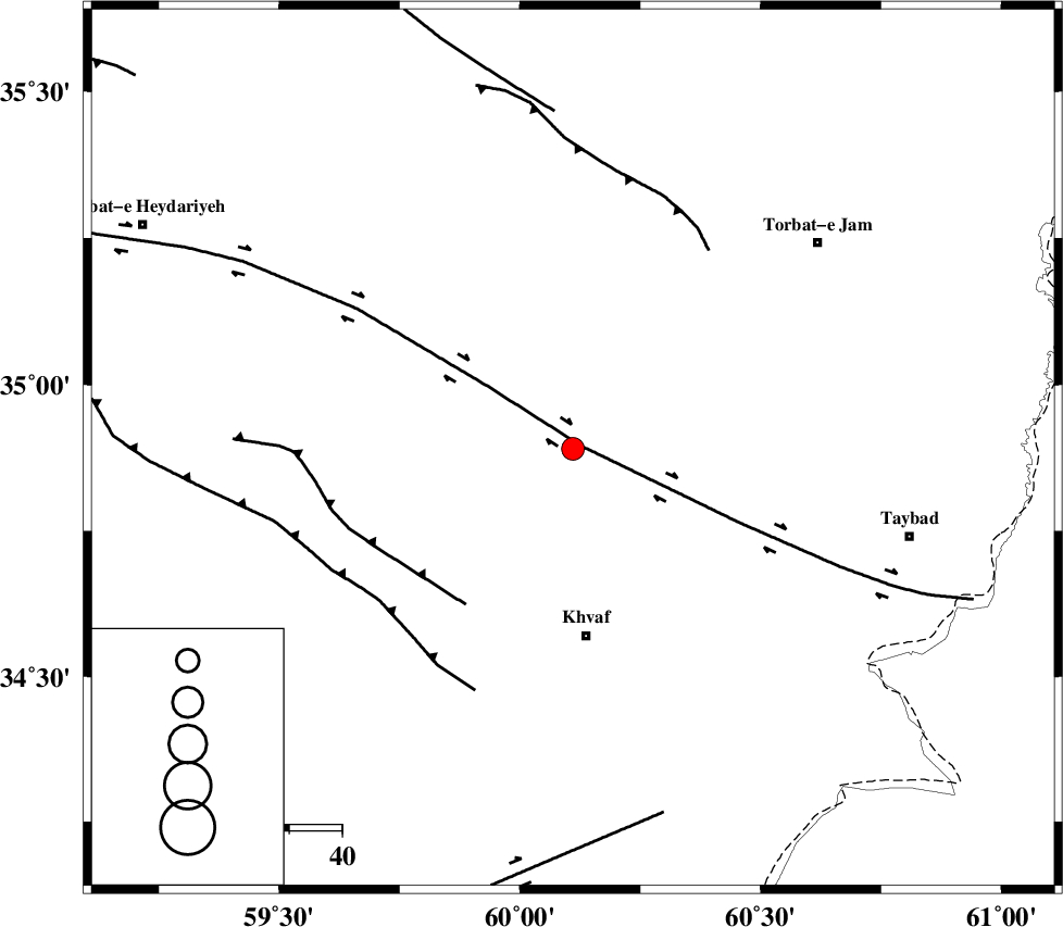
| Location | Lat:34.89 Lon: 60.11 |
| Region | Khorasan(center) Province, 36 km North of Khaf |
Nearest Cities |
|
| 20 km North East of Salami, Khorasan(center) Province | |
| 22 km West of Bakhazar, Khorasan(center) Province | |
| 23 km South of Ghalehno-e olia, Khorasan(center) Province | |
| 28 km North East of Chamanabad, Khorasan(center) Province | |
| 36 km North of Khaf, Khorasan(center) Province | |
| Depth | 18 km |
| Agency | |
Faults within 150 km: |
|
| DORUNEH_F (Length: 713 km) , Distance to epicenter: 2 km | |
| KHAF_F (Length: 58 km) , Distance to epicenter: 36 km | |
| TORBAT_E_JAM_F2 (Length: 57 km) , Distance to epicenter: 46 km | |
| Number of Phases | 6 |
| RMS | 0.1 |
| Number of Stations | 4 |
| Error in Latitude | >4 km |
| Error in Longitude | 2.5 km |
| Error in Depth | 4.6 km |
Download waveform in seisan format
to download seisan software Click here
to access information about IIEES stations Click here
Amplitude | ||||||||
| UID | Agency | Station | Component | Amplitude | Period | Arrival Time | Proccessing Time | Signal Clip |
| 96032 | IIEES | SHRT | E | 272.1 | 0.32 | 2015-06-24 19:33:12 | 2015-06-24 09:04:00 | n |
| 96033 | IIEES | SHRT | N | 272.6 | 0.48 | 2015-06-24 19:33:13 | 2015-06-24 09:04:00 | n |
| 96034 | IIEES | TABS | N | 81.5 | 0.44 | 2015-06-24 19:34:01 | 2015-06-24 09:04:00 | n |
| 96035 | IIEES | YZKH | E | 8.6 | 0.48 | 2015-06-24 19:35:17 | 2015-06-24 09:04:00 | n |
| 96036 | IIEES | YZKH | N | 6.9 | 0.44 | 2015-06-24 19:35:21 | 2015-06-24 09:04:00 | n |
Phase | ||||||||||||
| Agency | Station | Component | Phase Type | Phase Quality | First Motion | Observed Arrival Time | Time Residual | Loc. Flag | Input Weight | Distance | Azimuth | |
| IIEES | SHRT | Z | Pg | E | 2015-06-24 19:32:52 | 0.06 | y | 139 | 173 | |||
| IIEES | SHRT | E | Sg | E | 2015-06-24 19:33:09 | -0.05 | y | 139 | 173 | |||
| IIEES | TABS | Z | Pn | E | 2015-06-24 19:33:15 | -0.09 | y | 308 | 244 | |||
| IIEES | TABS | N | Sg | E | 2015-06-24 19:33:56 | 0.03 | y | 308 | 244 | |||
| IIEES | BSRN | Z | Pn | E | 2015-06-24 19:33:18 | 0.05 | y | 337 | 196 | |||
| IIEES | YZKH | Z | Pn | E | 2015-06-24 19:33:49 | 0.01 | y | 582 | 243 | |||