
Magnitude |
:3.7 |
| Date & Time (UTC) | 2015-06-18 00:53:22.2 |
| Date & Time (Local) | 1394/3/28 05:23:22.2 |
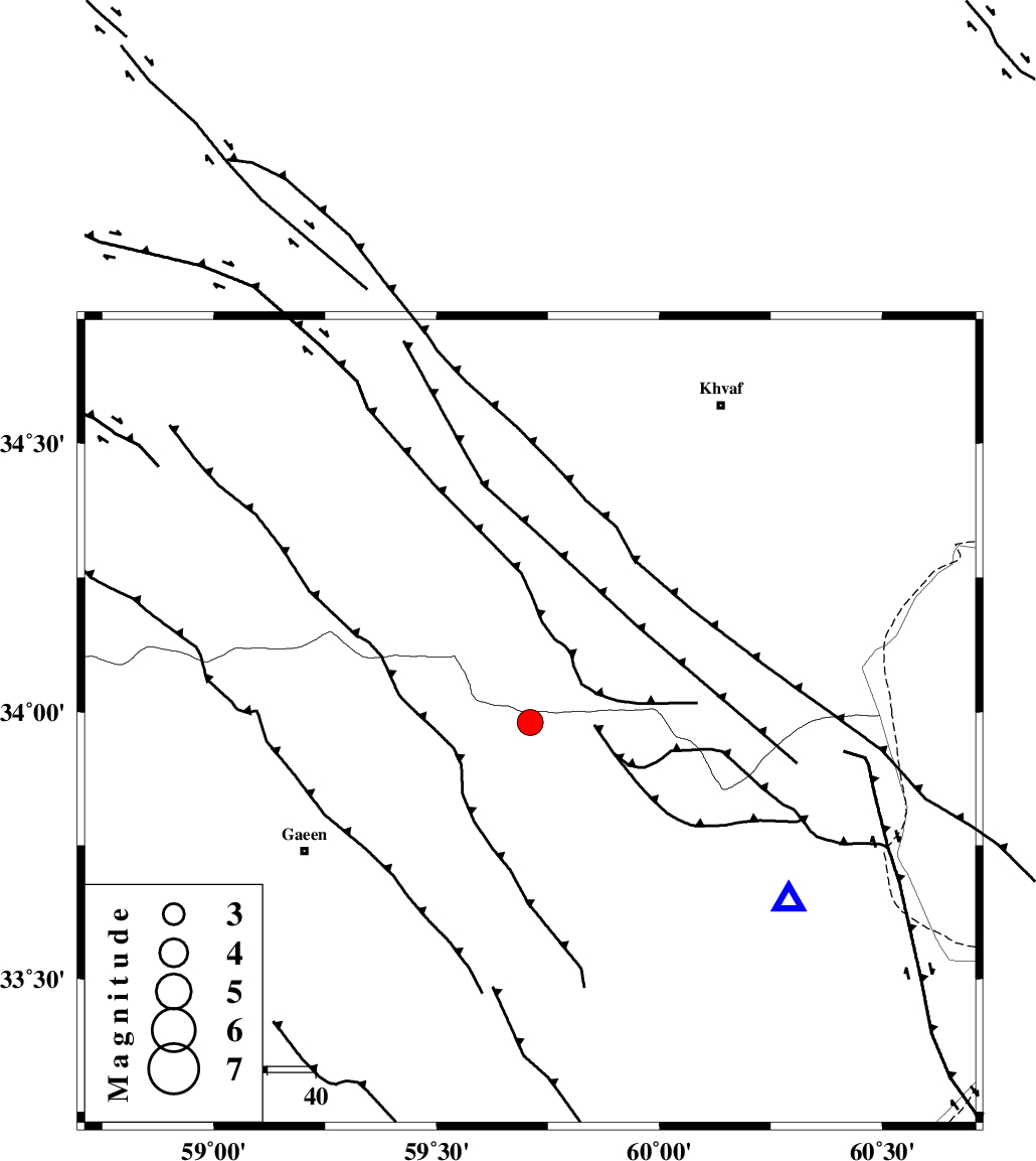
| Location | Lat:33.98 Lon: 59.71 |
| Region | 54 km North-East of Qaen |
Nearest Cities |
|
| 36 km South West of Ebrahimi, Khorasan(center) Province | |
| 39 km North West of Abiz, Khorasan(south) Province | |
| 43 km South West of Pasgah-e chazul, Khorasan(center) Province | |
| 44 km South West of Zuzan, Khorasan(center) Province | |
| 46 km South West of Qasemabad, Khorasan(center) Province | |
| Depth | 14 km |
| Agency | |
Faults within 150 km: |
|
| ABRIZ_F (Length: 114 km) , Distance to epicenter: 8 km | |
| DASHT_E_BAYAZ_F (Length: 177 km) , Distance to epicenter: 15 km | |
| JANGAL_F (Length: 111 km) , Distance to epicenter: 58 km | |
| Number of Phases | 7 |
| RMS | 0.2 |
| Number of Stations | 5 |
| Error in Latitude | >4.3 km |
| Error in Longitude | 1.9 km |
| Error in Depth | 4.7 km |
Download waveform in seisan format
to download seisan software Click here
to access information about IIEES stations Click here
Amplitude | ||||||||
| UID | Agency | Station | Component | Amplitude | Period | Arrival Time | Proccessing Time | Signal Clip |
| 95973 | IIEES | SHRT | N | 3856.2 | 0.24 | 2015-06-18 00:53:42 | 2015-06-18 02:17:00 | n |
| 95974 | IIEES | SHRT | E | 4652 | 0.12 | 2015-06-18 00:53:44 | 2015-06-18 02:17:00 | n |
Phase | ||||||||||||
| Agency | Station | Component | Phase Type | Phase Quality | First Motion | Observed Arrival Time | Time Residual | Loc. Flag | Input Weight | Distance | Azimuth | |
| IIEES | SHRT | Z | Pg | E | 2015-06-18 00:53:33 | -0.13 | y | 65.5 | 125 | |||
| IIEES | SHRT | E | Sg | E | 2015-06-18 00:53:42 | 0.04 | y | 65.5 | 125 | |||
| IIEES | TABS | Z | Pn | E | 2015-06-18 00:54:00 | 0.28 | y | 243 | 262 | |||
| IIEES | TABS | E | Sg | E | 2015-06-18 00:54:30 | -0.19 | y | 243 | 262 | |||
| IIEES | SHRO | Z | Pn | E | 2015-06-18 00:54:20 | -0.11 | y | 405 | 305 | |||
| IIEES | YZKH | Z | Pn | E | 2015-06-18 00:54:33 | 0 | y | 509 | 251 | |||
| IIEES | KRBR | Z | Pn | E | 2015-06-18 00:54:35 | 0.14 | y | 524 | 213 | |||