
Magnitude |
:3.3 |
| Date & Time (UTC) | 2015-06-17 20:32:23.2 |
| Date & Time (Local) | 1394/3/28 01:02:23.2 |
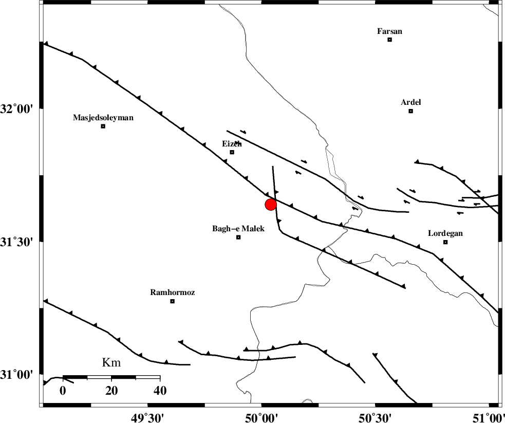
| Location | Lat:31.64 Lon: 50.04 |
| Region | Khoozestan Province, 19 km North-East of Bagh Malek |
Nearest Cities |
|
| 11 km North of Abolabbas, Khoozestan Province | |
| 14 km North East of Ghaleh tal, Khoozestan Province | |
| 19 km North East of Bagh Malek, Khoozestan Province | |
| 25 km South West of Dehdez, Khoozestan Province | |
| 27 km South East of Izeh, Khoozestan Province | |
| Depth | 18 km |
| Agency | |
Faults within 150 km: |
|
| MFF2 (Length: 205 km) , Distance to epicenter: 7 km | |
| DEZFUL_EMBAYMENT (Length: 228 km) , Distance to epicenter: 35 km | |
| SABZKUH_F (Length: 67 km) , Distance to epicenter: 39 km | |
| Number of Phases | 7 |
| RMS | 0.1 |
| Number of Stations | 5 |
| Error in Latitude | >2.6 km |
| Error in Longitude | 2.6 km |
| Error in Depth | 5 km |
Download waveform in seisan format
to download seisan software Click here
to access information about IIEES stations Click here
Amplitude | ||||||||
| UID | Agency | Station | Component | Amplitude | Period | Arrival Time | Proccessing Time | Signal Clip |
| 95969 | IIEES | SHGR | N | 668.8 | 0.56 | 2015-06-17 20:33:02 | 2015-06-17 09:57:00 | n |
| 95970 | IIEES | SHGR | E | 496.1 | 0.36 | 2015-06-17 20:33:08 | 2015-06-17 09:57:00 | n |
Phase | ||||||||||||
| Agency | Station | Component | Phase Type | Phase Quality | First Motion | Observed Arrival Time | Time Residual | Loc. Flag | Input Weight | Distance | Azimuth | |
| IIEES | SHGR | Z | Pg | E | 2015-06-17 20:32:44 | 0 | y | 129 | 294 | |||
| IIEES | SHGR | N | Sg | E | 2015-06-17 20:33:00 | 0.06 | y | 129 | 294 | |||
| IIEES | KHMZ | Z | Pn | E | 2015-06-17 20:32:59 | -0.12 | y | 233 | 358 | |||
| IIEES | NASN | Z | Pn | E | 2015-06-17 20:33:07 | 0.14 | y | 291 | 63 | |||
| IIEES | ASAO | Z | Pn | E | 2015-06-17 20:33:10 | -0.13 | y | 323 | 360 | |||
| IIEES | ASAO | E | Sg | E | 2015-06-17 20:33:54 | 0.07 | y | 323 | 360 | |||
| IIEES | GHVR | Z | Pn | E | 2015-06-17 20:33:12 | -0.02 | y | 335 | 19 | |||