
Magnitude |
:2.8 |
| Date & Time (UTC) | 2015-06-05 11:24:43.6 |
| Date & Time (Local) | 1394/3/15 15:54:43.6 |
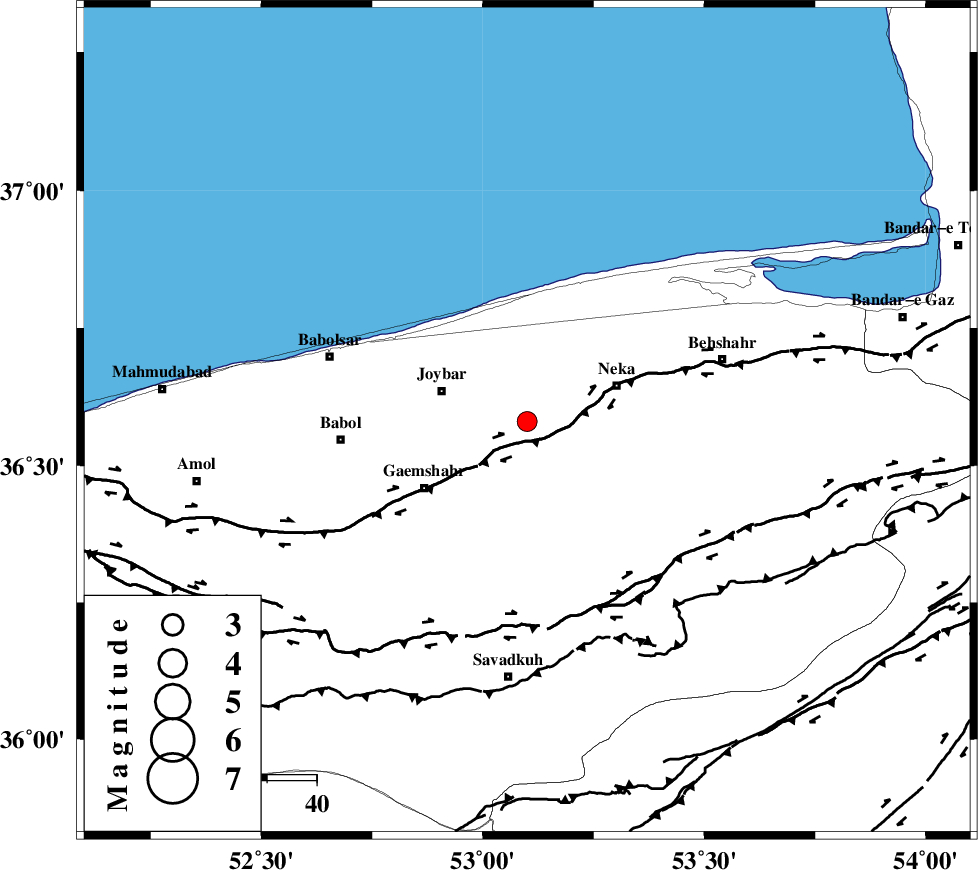
| Location | Lat:36.58 Lon: 53.1 |
| Region | Mazandaran Province, 4 km Sari |
Nearest Cities |
|
| 4 km North of Sari, Mazandaran Province | |
| 10 km West of Surak, Mazandaran Province | |
| 12 km North of Sangtarashan, Mazandaran Province | |
| 13 km East of Gelird, Mazandaran Province | |
| 17 km North East of Rekabdar kola, Mazandaran Province | |
| Depth | 14 km |
| Agency | |
Faults within 150 km: |
|
| KHAZAR_F (Length: 523 km) , Distance to epicenter: 5 km | |
| N_ALBORZ_F (Length: 360 km) , Distance to epicenter: 39 km | |
| DAMGHAN_F (Length: 95 km) , Distance to epicenter: 82 km | |
| Number of Phases | 5 |
| RMS | 0.2 |
| Number of Stations | 3 |
| Error in Latitude | >4.9 km |
| Error in Longitude | 8.5 km |
| Error in Depth | 9.4 km |
Download waveform in seisan format
to download seisan software Click here
to access information about IIEES stations Click here
Amplitude | ||||||||
| UID | Agency | Station | Component | Amplitude | Period | Arrival Time | Proccessing Time | Signal Clip |
| 95881 | IIEES | THKV | N | 46.5 | 0.42 | 2015-06-05 11:25:51 | 2015-06-05 12:57:00 | n |
| 95882 | IIEES | GHVR | N | 60.1 | 0.52 | 2015-06-05 11:26:10 | 2015-06-05 12:57:00 | n |
| 95883 | IIEES | GHVR | E | 41.3 | 0.48 | 2015-06-05 11:26:10 | 2015-06-05 12:57:00 | n |
Phase | ||||||||||||
| Agency | Station | Component | Phase Type | Phase Quality | First Motion | Observed Arrival Time | Time Residual | Loc. Flag | Input Weight | Distance | Azimuth | |
| IIEES | CHTH | E | Pg | E | 2015-06-05 11:25:15 | -0.15 | y | 192 | 248 | |||
| IIEES | THKV | Z | Pn | E | 2015-06-05 11:25:17 | -0.2 | y | 213 | 250 | |||
| IIEES | THKV | N | Sg | E | 2015-06-05 11:25:44 | 0.17 | y | 213 | 250 | |||
| IIEES | GHVR | Z | Pn | E | 2015-06-05 11:25:27 | 0.33 | y | 287 | 216 | |||
| IIEES | GHVR | E | Sg | E | 2015-06-05 11:26:04 | -0.14 | y | 287 | 216 | |||