
Magnitude |
:3.4 |
| Date & Time (UTC) | 2015-06-03 19:33:35.3 |
| Date & Time (Local) | 1394/3/14 00:03:35.3 |
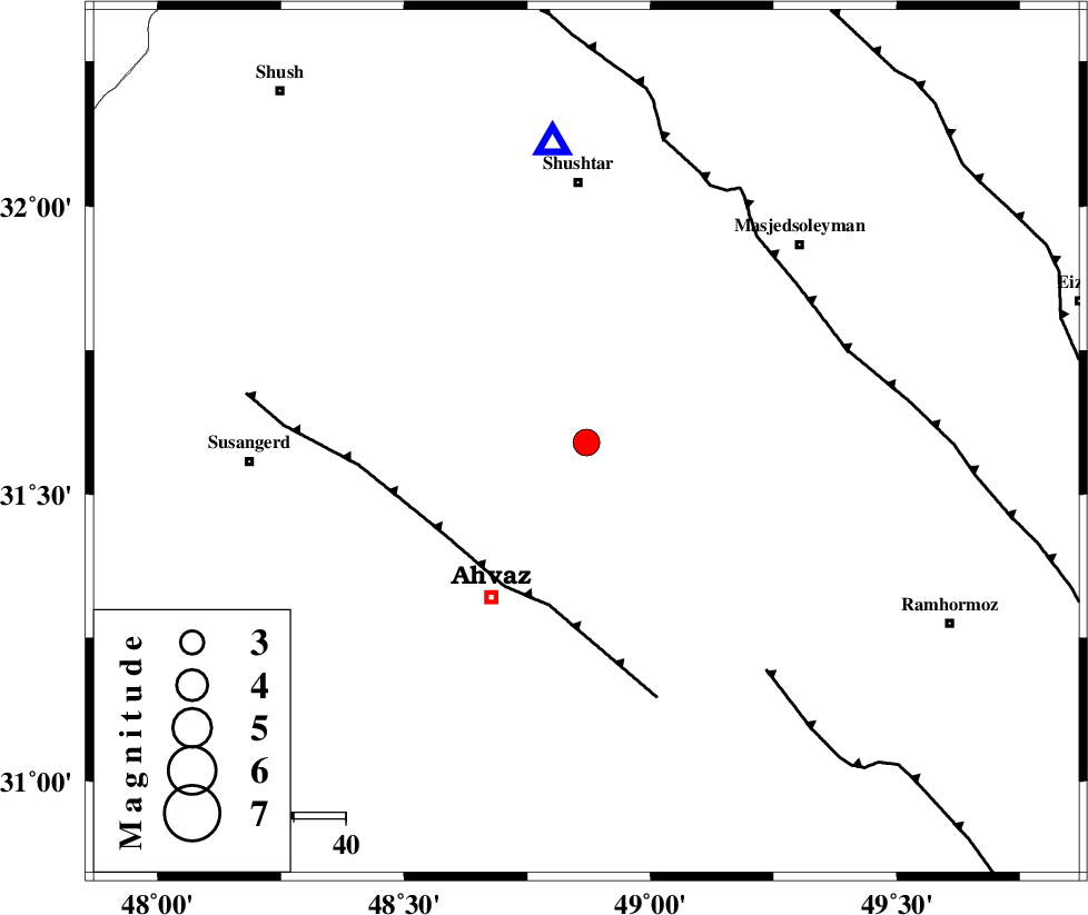
| Location | Lat:31.59 Lon: 48.87 |
| Region | Khoozestan Province, 35 km North-East of Ahvaz |
Nearest Cities |
|
| 1 km North of Mollasani, Khoozestan Province | |
| 7 km of Talieh, Khoozestan Province | |
| 12 km North of Veys, Khoozestan Province | |
| 27 km South of Arabhasan, Khoozestan Province | |
| 35 km North East of Ahvaz, Khoozestan Province | |
| Depth | 10 km |
| Agency | |
Faults within 150 km: |
|
| AHVAZ_F (Length: 99 km) , Distance to epicenter: 32 km | |
| DEZFUL_EMBAYMENT (Length: 228 km) , Distance to epicenter: 51 km | |
| AGHAJARI_F (Length: 88 km) , Distance to epicenter: 56 km | |
| Number of Phases | 9 |
| RMS | 0.1 |
| Number of Stations | 8 |
| Error in Latitude | >2.3 km |
| Error in Longitude | 4.4 km |
| Error in Depth | 3.6 km |
Download waveform in seisan format
to download seisan software Click here
to access information about IIEES stations Click here
Amplitude | ||||||||
| UID | Agency | Station | Component | Amplitude | Period | Arrival Time | Proccessing Time | Signal Clip |
| 95865 | IIEES | AHRM | N | 79 | 0.4 | 2015-06-03 19:35:15 | 2015-06-03 09:03:00 | n |
Phase | ||||||||||||
| Agency | Station | Component | Phase Type | Phase Quality | First Motion | Observed Arrival Time | Time Residual | Loc. Flag | Input Weight | Distance | Azimuth | |
| IIEES | SHGR | Z | Pg | E | 2015-06-03 19:33:45 | 0.13 | y | 58.1 | 354 | |||
| IIEES | SHGR | N | Sg | E | 2015-06-03 19:33:53 | -0.12 | y | 58.1 | 354 | |||
| IIEES | KHMZ | Z | Pn | E | 2015-06-03 19:34:15 | 0.02 | y | 260 | 23 | |||
| IIEES | ASAO | Z | Pn | E | 2015-06-03 19:34:26 | 0.2 | y | 346 | 18 | |||
| IIEES | AHRM | Z | Pn | E | 2015-06-03 19:34:30 | 0 | y | 382 | 142 | |||
| IIEES | GHVR | Z | Pn | E | 2015-06-03 19:34:32 | 0.14 | y | 390 | 34 | |||
| IIEES | NASN | Z | Pn | E | 2015-06-03 19:34:32 | -0.13 | y | 395 | 69 | |||
| IIEES | SNGE | Z | Pn | E | 2015-06-03 19:34:34 | -0.17 | y | 414 | 340 | |||
| IIEES | YZKH | Z | Pn | E | 2015-06-03 19:34:51 | -0.13 | y | 548 | 79 | |||