
Magnitude |
:3.1 |
| Date & Time (UTC) | 2015-06-03 17:49:20.4 |
| Date & Time (Local) | 1394/3/13 22:19:20.4 |
| Location | Lat:34.16 Lon: 48.58 |
| Region | Hamedan Province, 20 km East of Nahavand |
Nearest Cities |
|
| 5 km North of Anuj, Hamedan Province | |
| 7 km North of Kahakdan, Hamedan Province | |
| 11 km North of Jaefarabad, Lorestan Province | |
| 13 km West of Saman, Hamedan Province | |
| 14 km of Avarzman, Hamedan Province | |
| Depth | 16 km |
| Agency | |
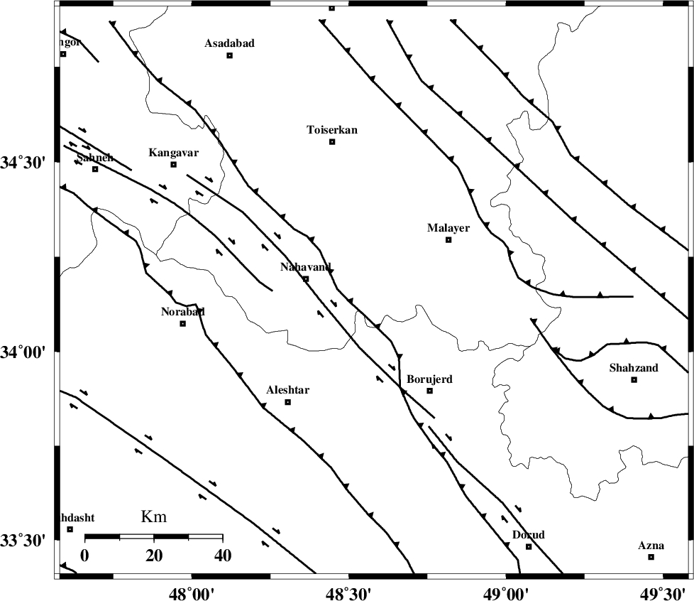
Faults within 150 km: |
|
| NAHAVAND_F (Length: 102 km) , Distance to epicenter: 16 km | |
| SAHANEH_F (Length: 77 km) , Distance to epicenter: 30 km | |
| DORUD (Length: 100 km) , Distance to epicenter: 43 km | |
| Number of Phases | 6 |
| RMS | 0.1 |
| Number of Stations | 5 |
| Error in Latitude | >2.9 km |
| Error in Longitude | 1.6 km |
| Error in Depth | 3.7 km |
Download waveform in seisan format
to download seisan software Click here
to access information about IIEES stations Click here
Amplitude | ||||||||
| UID | Agency | Station | Component | Amplitude | Period | Arrival Time | Proccessing Time | Signal Clip |
| 95863 | IIEES | GHVR | N | 122.1 | 0.36 | 2015-06-03 17:50:35 | 2015-06-03 07:08:00 | n |
| 95864 | IIEES | GHVR | E | 98.3 | 0.48 | 2015-06-03 17:50:35 | 2015-06-03 07:08:00 | n |
Phase | ||||||||||||
| Agency | Station | Component | Phase Type | Phase Quality | First Motion | Observed Arrival Time | Time Residual | Loc. Flag | Input Weight | Distance | Azimuth | |
| IIEES | KHMZ | Z | Pg | E | 2015-06-03 17:49:43 | -0.04 | y | 136 | 110 | |||
| IIEES | ASAO | Z | Pg | E | 2015-06-03 17:49:43 | 0.07 | y | 140 | 72 | |||
| IIEES | SNGE | Z | Pg | E | 2015-06-03 17:49:45 | 0.07 | y | 153 | 313 | |||
| IIEES | SNGE | N | Sg | E | 2015-06-03 17:50:04 | -0.06 | y | 153 | 313 | |||
| IIEES | GHVR | E | Sg | E | 2015-06-03 17:50:30 | -0.03 | y | 248 | 81 | |||
| IIEES | CHTH | Z | Pn | E | 2015-06-03 17:50:05 | 0 | y | 303 | 49 | |||