
Magnitude |
:1.6 |
| Date & Time (UTC) | 2015-06-03 14:16:42.7 |
| Date & Time (Local) | 1394/3/13 18:46:42.7 |
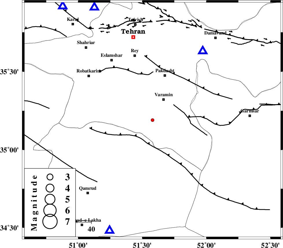
| Location | Lat:35.19 Lon: 51.58 |
| Region | Tehran Province, 17 km South of Varamin |
Nearest Cities |
|
| 8 km of Ab barik, Tehran Province | |
| 16 km South of Bagh-e khavas, Tehran Province | |
| 17 km South of Varamin, Tehran Province | |
| 19 km South West of Pishva, Tehran Province | |
| 24 km South West of Khalilabad, Tehran Province | |
| Depth | 36 km |
| Agency | |
Faults within 150 km: |
|
| SIAHKUH_F (Length: 154 km) , Distance to epicenter: 16 km | |
| PISHAV_F (Length: 34 km) , Distance to epicenter: 19 km | |
| GARMSAR_F (Length: 77 km) , Distance to epicenter: 25 km | |
| Number of Phases | 7 |
| RMS | 0.1 |
| Number of Stations | 4 |
| Error in Latitude | >0.9 km |
| Error in Longitude | 1.9 km |
| Error in Depth | 2.4 km |
Download waveform in seisan format
to download seisan software Click here
to access information about IIEES stations Click here
Amplitude | ||||||||
| UID | Agency | Station | Component | Amplitude | Period | Arrival Time | Proccessing Time | Signal Clip |
| 95861 | IIEES | GHVR | E | 19.4 | 0.24 | 2015-06-03 14:17:08 | 2015-06-03 05:53:00 | n |
| 95862 | IIEES | GHVR | N | 20.2 | 0.36 | 2015-06-03 14:17:09 | 2015-06-03 05:53:00 | n |
Phase | ||||||||||||
| Agency | Station | Component | Phase Type | Phase Quality | First Motion | Observed Arrival Time | Time Residual | Loc. Flag | Input Weight | Distance | Azimuth | |
| IIEES | DAMV | Z | Pg | E | 2015-06-03 14:16:54 | 0.08 | y | 60.7 | 36 | |||
| IIEES | GHVR | Z | Pg | E | 2015-06-03 14:16:57 | -0.07 | y | 84.1 | 201 | |||
| IIEES | GHVR | N | Sg | E | 2015-06-03 14:17:08 | -0.04 | y | 84.1 | 201 | |||
| IIEES | CHTH | Z | Pg | E | 2015-06-03 14:16:58 | 0.07 | y | 90 | 333 | |||
| IIEES | CHTH | E | Sg | E | 2015-06-03 14:17:10 | -0.12 | y | 90 | 333 | |||
| IIEES | ASAO | Z | Pn | E | 2015-06-03 14:17:08 | -0.03 | y | 159 | 244 | |||
| IIEES | ASAO | E | Sg | E | 2015-06-03 14:17:28 | 0.11 | y | 159 | 244 | |||