
Magnitude |
:2.3 |
| Date & Time (UTC) | 2015-06-02 22:46:53.4 |
| Date & Time (Local) | 1394/3/13 03:16:53.4 |
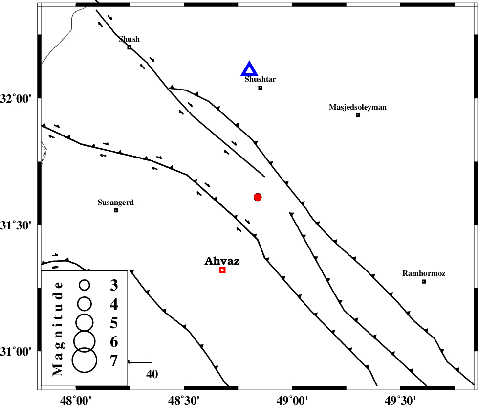
| Location | Lat:31.61 Lon: 48.84 |
| Region | Khoozestan Province, 48 km South of Shushtar |
Nearest Cities |
|
| 4 km North of Mollasani, Khoozestan Province | |
| 9 km North of Talieh, Khoozestan Province | |
| 14 km North of Veys, Khoozestan Province | |
| 25 km South of Arabhasan, Khoozestan Province | |
| 36 km North East of Ahvaz, Khoozestan Province | |
| Depth | 14 km |
| Agency | |
Faults within 150 km: |
|
| AHVAZ_F (Length: 99 km) , Distance to epicenter: 32 km | |
| DEZFUL_EMBAYMENT (Length: 228 km) , Distance to epicenter: 52 km | |
| AGHAJARI_F (Length: 88 km) , Distance to epicenter: 59 km | |
| Number of Phases | 5 |
| RMS | 0.1 |
| Number of Stations | 3 |
| Error in Latitude | >3.4 km |
| Error in Longitude | 3.6 km |
| Error in Depth | 6.2 km |
Download waveform in seisan format
to download seisan software Click here
to access information about IIEES stations Click here
Amplitude | ||||||||
| UID | Agency | Station | Component | Amplitude | Period | Arrival Time | Proccessing Time | Signal Clip |
| 95856 | IIEES | SHGR | E | 209.9 | 0.6 | 2015-06-02 22:47:17 | 2015-06-03 12:28:00 | n |
| 95857 | IIEES | NASN | E | 5.4 | 0.4 | 2015-06-02 22:48:35 | 2015-06-03 12:28:00 | n |
Phase | ||||||||||||
| Agency | Station | Component | Phase Type | Phase Quality | First Motion | Observed Arrival Time | Time Residual | Loc. Flag | Input Weight | Distance | Azimuth | |
| IIEES | SHGR | Z | Pg | E | 2015-06-02 22:47:03 | -0.08 | y | 55.7 | 356 | |||
| IIEES | SHGR | N | Sg | E | 2015-06-02 22:47:10 | 0.06 | y | 55.7 | 356 | |||
| IIEES | KHMZ | Z | Pn | E | 2015-06-02 22:47:33 | 0.03 | y | 259 | 24 | |||
| IIEES | KHMZ | Z | Sg | E | 2015-06-02 22:48:06 | -0.04 | y | 259 | 24 | |||
| IIEES | NASN | Z | Pn | E | 2015-06-02 22:47:50 | 0.03 | y | 397 | 69 | |||