
Magnitude |
:3.1 |
| Date & Time (UTC) | 2015-05-25 20:32:27.9 |
| Date & Time (Local) | 1394/3/5 01:02:27.9 |
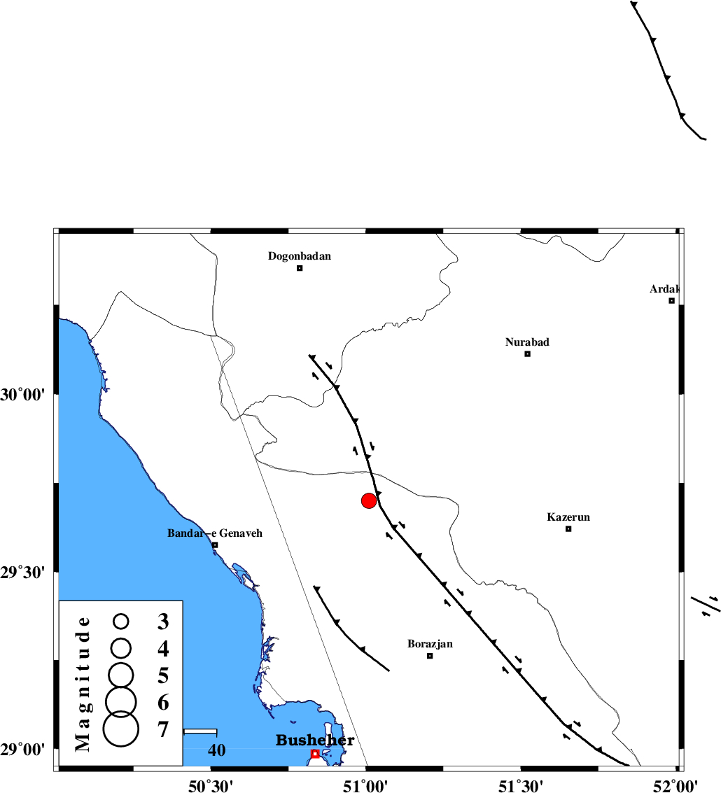
| Location | Lat:29.7 Lon: 51.01 |
| Region | Bushehr Province, 50 km North-East of Bandar-e genaveh |
Nearest Cities |
|
| 25 km North of Dehkohneh, Bushehr Province | |
| 28 km North East of Chehar rustaee, Bushehr Province | |
| 35 km North West of Khesht, Fars Province | |
| 37 km North West of Saedabad, Bushehr Province | |
| 39 km North East of Mohammad salehi, Bushehr Province | |
| Depth | 46 km |
| Agency | |
Faults within 150 km: |
|
| ZFF3 (Length: 125 km) , Distance to epicenter: 17 km | |
| BORAZJAN_F (Length: 168 km) , Distance to epicenter: 29 km | |
| KAZERUN_F (Length: 96 km) , Distance to epicenter: 50 km | |
| Number of Phases | 8 |
| RMS | 0.1 |
| Number of Stations | 7 |
| Error in Latitude | >3.8 km |
| Error in Longitude | 4.4 km |
| Error in Depth | 5.9 km |
Download waveform in seisan format
to download seisan software Click here
to access information about IIEES stations Click here
Amplitude | ||||||||
| UID | Agency | Station | Component | Amplitude | Period | Arrival Time | Proccessing Time | Signal Clip |
| 95793 | IIEES | BNDS | N | 11.2 | 0.4 | 2015-05-25 20:34:44 | 2015-05-26 12:26:00 | n |
| 95794 | IIEES | BNDS | E | 9.6 | 0.4 | 2015-05-25 20:34:44 | 2015-05-26 12:26:00 | n |
Phase | ||||||||||||
| Agency | Station | Component | Phase Type | Phase Quality | First Motion | Observed Arrival Time | Time Residual | Loc. Flag | Input Weight | Distance | Azimuth | |
| IIEES | AHRM | E | Pg | E | 2015-05-25 20:32:45 | 0.06 | y | 97 | 163 | |||
| IIEES | AHRM | E | Sg | E | 2015-05-25 20:32:57 | -0.05 | y | 97 | 163 | |||
| IIEES | NASN | Z | Pn | E | 2015-05-25 20:33:20 | 0.03 | y | 384 | 26 | |||
| IIEES | YZKH | Z | Pn | E | 2015-05-25 20:33:29 | -0.12 | y | 454 | 48 | |||
| IIEES | ASAO | Z | Pn | E | 2015-05-25 20:33:40 | 0.17 | y | 545 | 350 | |||
| IIEES | KRBR | Z | Pn | E | 2015-05-25 20:33:42 | 0.03 | y | 557 | 85 | |||
| IIEES | BNDS | E | Pn | E | 2015-05-25 20:33:43 | 0.03 | y | 566 | 116 | |||
| IIEES | SNGE | Z | Pn | E | 2015-05-25 20:33:58 | -0.19 | y | 690 | 331 | |||