
Magnitude |
:3.5 |
| Date & Time (UTC) | 2015-05-22 14:49:43.8 |
| Date & Time (Local) | 1394/3/1 19:19:43.8 |
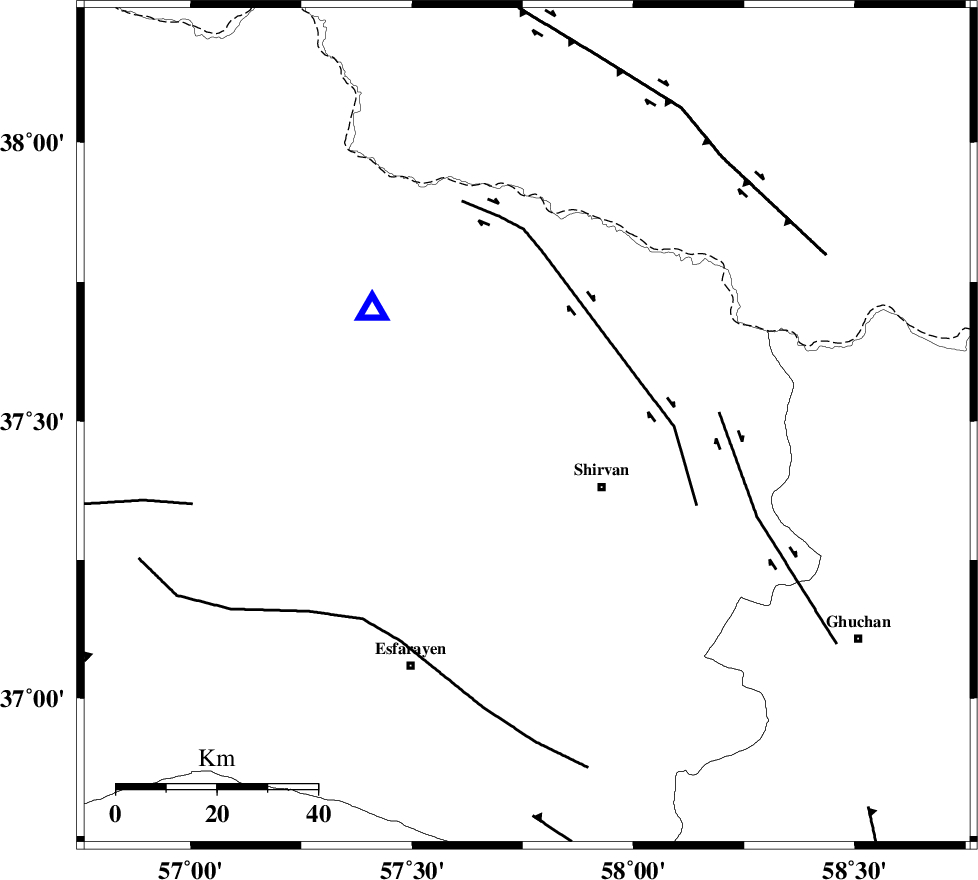
| Location | Lat:37.49 Lon: 57.76 |
| Region | Khorasan(north) Province, 19 km North-West of Shirvan |
Nearest Cities |
|
| 13 km North West of Ziyarat, Khorasan(north) Province | |
| 16 km South of Tukur, Khorasan(north) Province | |
| 16 km South West of Lojali, Khorasan(north) Province | |
| 19 km North West of Shirvan, Khorasan(north) Province | |
| 20 km North of Zavarom, Khorasan(north) Province | |
| Depth | 14 km |
| Agency | |
Faults within 150 km: |
|
| BAGHAN_GERMAB_F (Length: 79 km) , Distance to epicenter: 24 km | |
| GHUCHAN_F (Length: 50 km) , Distance to epicenter: 38 km | |
| ESFARAYEN_F (Length: 111 km) , Distance to epicenter: 50 km | |
| Number of Phases | 6 |
| RMS | 0.1 |
| Number of Stations | 4 |
| Error in Latitude | >3.4 km |
| Error in Longitude | 3.8 km |
| Error in Depth | 8.1 km |
Download waveform in seisan format
to download seisan software Click here
to access information about IIEES stations Click here
Amplitude | ||||||||
| UID | Agency | Station | Component | Amplitude | Period | Arrival Time | Proccessing Time | Signal Clip |
| 95770 | IIEES | MRVT | N | 846.1 | 0.44 | 2015-05-22 14:50:31 | 2015-05-22 04:08:00 | n |
| 95771 | IIEES | MRVT | E | 745.8 | 0.36 | 2015-05-22 14:50:32 | 2015-05-22 04:08:00 | n |
Phase | ||||||||||||
| Agency | Station | Component | Phase Type | Phase Quality | First Motion | Observed Arrival Time | Time Residual | Loc. Flag | Input Weight | Distance | Azimuth | |
| IIEES | BJRD | Z | Pg | E | 2015-05-22 14:49:51 | 0.09 | y | 38.8 | 306 | |||
| IIEES | BJRD | E | Sg | E | 2015-05-22 14:49:56 | -0.02 | y | 38.8 | 306 | |||
| IIEES | MRVT | Z | Pg | E | 2015-05-22 14:50:08 | -0.15 | y | 149 | 278 | |||
| IIEES | MRVT | N | Sg | E | 2015-05-22 14:50:26 | 0.03 | y | 149 | 278 | |||
| IIEES | SHRO | Z | Pn | E | 2015-05-22 14:50:19 | 0.11 | y | 227 | 224 | |||
| IIEES | TABS | Z | Pn | E | 2015-05-22 14:50:44 | -0.07 | y | 430 | 188 | |||