
Magnitude |
:4.5 |
| Date & Time (UTC) | 2015-05-10 22:08:58.3 |
| Date & Time (Local) | 1394/2/21 02:38:58.3 |
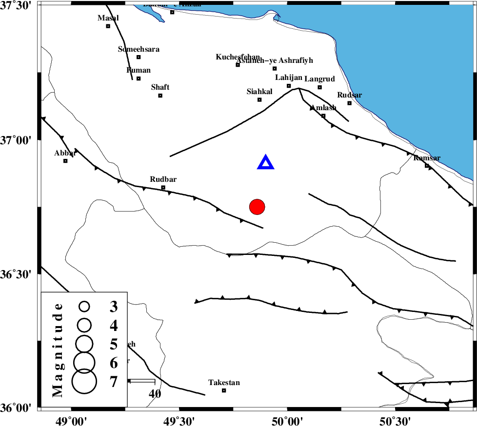
| Location | Lat:36.75 Lon: 49.86 |
| Region | Gilan Province, 44 km South of Siahkal |
Nearest Cities |
|
| 9 km North of Jirhandeh, Gilan Province | |
| 11 km North West of Kelishom, Gilan Province | |
| 12 km South of Barresar, Gilan Province | |
| 21 km South East of Dashtvil, Gilan Province | |
| 32 km South of Khorma, Gilan Province | |
| Depth | 16 km |
| Agency | |
Faults within 150 km: |
|
| RUDBAR_F (Length: 93 km) , Distance to epicenter: 9 km | |
| ALAMUTRUD_F (Length: 140 km) , Distance to epicenter: 19 km | |
| BONAN_F (Length: 74 km) , Distance to epicenter: 22 km | |
| Number of Phases | 9 |
| RMS | 0.4 |
| Number of Stations | 7 |
| Error in Latitude | >5.2 km |
| Error in Longitude | 4.3 km |
| Error in Depth | 8.9 km |
Download waveform in seisan format
to download seisan software Click here
to access information about IIEES stations Click here
Amplitude | ||||||||
| UID | Agency | Station | Component | Amplitude | Period | Arrival Time | Proccessing Time | Signal Clip |
| 95643 | IIEES | THKV | N | 8633 | 0.32 | 2015-05-10 22:09:44 | 2015-05-10 11:58:00 | n |
| 95644 | IIEES | GHVR | E | 1974.2 | 0.64 | 2015-05-10 22:10:28 | 2015-05-10 11:58:00 | n |
Phase | ||||||||||||
| Agency | Station | Component | Phase Type | Phase Quality | First Motion | Observed Arrival Time | Time Residual | Loc. Flag | Input Weight | Distance | Azimuth | |
| IIEES | ZNJK | Z | Pg | E | 2015-05-10 22:09:16 | 0.2 | y | 105 | 266 | |||
| IIEES | THKV | Z | Pg | E | 2015-05-10 22:09:20 | -0.21 | y | 130 | 135 | |||
| IIEES | THKV | N | Sg | E | 2015-05-10 22:09:36 | -0.24 | y | 130 | 135 | |||
| IIEES | CHTH | Z | Pg | E | 2015-05-10 22:09:23 | 0.29 | y | 147 | 129 | |||
| IIEES | CHTH | E | Sg | E | 2015-05-10 22:09:41 | 0.2 | y | 147 | 129 | |||
| IIEES | ASAO | Z | Pn | E | 2015-05-10 22:09:37 | 0.84 | y | 245 | 176 | |||
| IIEES | ASAO | E | Sg | E | 2015-05-10 22:10:07 | -0.23 | y | 245 | 176 | |||
| IIEES | SNGE | Z | Pn | E | 2015-05-10 22:09:41 | -0.6 | y | 292 | 232 | |||
| IIEES | MRVT | Z | Pn | E | 2015-05-10 22:10:15 | -0.47 | y | 562 | 78 | |||