
Magnitude |
:3.6 |
| Date & Time (UTC) | 2015-05-09 09:48:23.5 |
| Date & Time (Local) | 1394/2/19 14:18:23.5 |
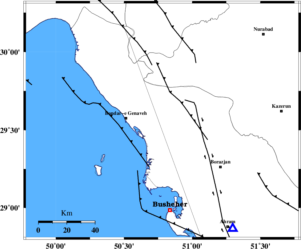
| Location | Lat:29.56 Lon: 50.78 |
| Region | Bushehr Province, 26 km East of Bandar-e genaveh |
Nearest Cities |
|
| 1 km North of Chehar rustaee, Bushehr Province | |
| 17 km North East of Bandarehrig, Bushehr Province | |
| 19 km East of Mohammad salehi, Bushehr Province | |
| 23 km North West of Dehkohneh, Bushehr Province | |
| 26 km East of Bandar-e genaveh, Bushehr Province | |
| Depth | 17 km |
| Agency | |
Faults within 150 km: |
|
| ZFF3 (Length: 125 km) , Distance to epicenter: 9 km | |
| BORAZJAN_F (Length: 168 km) , Distance to epicenter: 45 km | |
| KAZERUN_F (Length: 96 km) , Distance to epicenter: 72 km | |
| Number of Phases | 6 |
| RMS | 0.1 |
| Number of Stations | 7 |
| Error in Latitude | >5.4 km |
| Error in Longitude | 9.9 km |
| Error in Depth | 9.8 km |
Download waveform in seisan format
to download seisan software Click here
to access information about IIEES stations Click here
Amplitude | ||||||||
| UID | Agency | Station | Component | Amplitude | Period | Arrival Time | Proccessing Time | Signal Clip |
| 95620 | IIEES | SHGR | N | 180.8 | 0.34 | 2015-05-09 09:49:55 | 2015-05-09 11:45:00 | n |
Phase | ||||||||||||
| Agency | Station | Component | Phase Type | Phase Quality | First Motion | Observed Arrival Time | Time Residual | Loc. Flag | Input Weight | Distance | Azimuth | |
| IIEES | AHRM | Z | Pg | E | 2015-05-09 09:48:39 | 0 | y | 91.7 | 146 | |||
| IIEES | NASN | Z | Pn | E | 2015-05-09 09:49:21 | -0.05 | y | 408 | 28 | |||
| IIEES | YZKH | Z | P | E | 2015-05-09 09:49:30 | 0.06 | y | 481 | 48 | |||
| IIEES | GHVR | Z | Pn | E | 2015-05-09 09:49:39 | 0.16 | y | 548 | 5 | |||
| IIEES | BNDS | Z | Pn | E | 2015-05-09 09:49:43 | -0.01 | y | 580 | 113 | |||
| IIEES | DAMV | Z | P | E | 2015-05-09 09:49:55 | -0.2 | y | 683 | 9 | |||