
Magnitude |
:1.6 |
| Date & Time (UTC) | 2015-05-05 08:27:18.5 |
| Date & Time (Local) | 1394/2/15 12:57:18.5 |
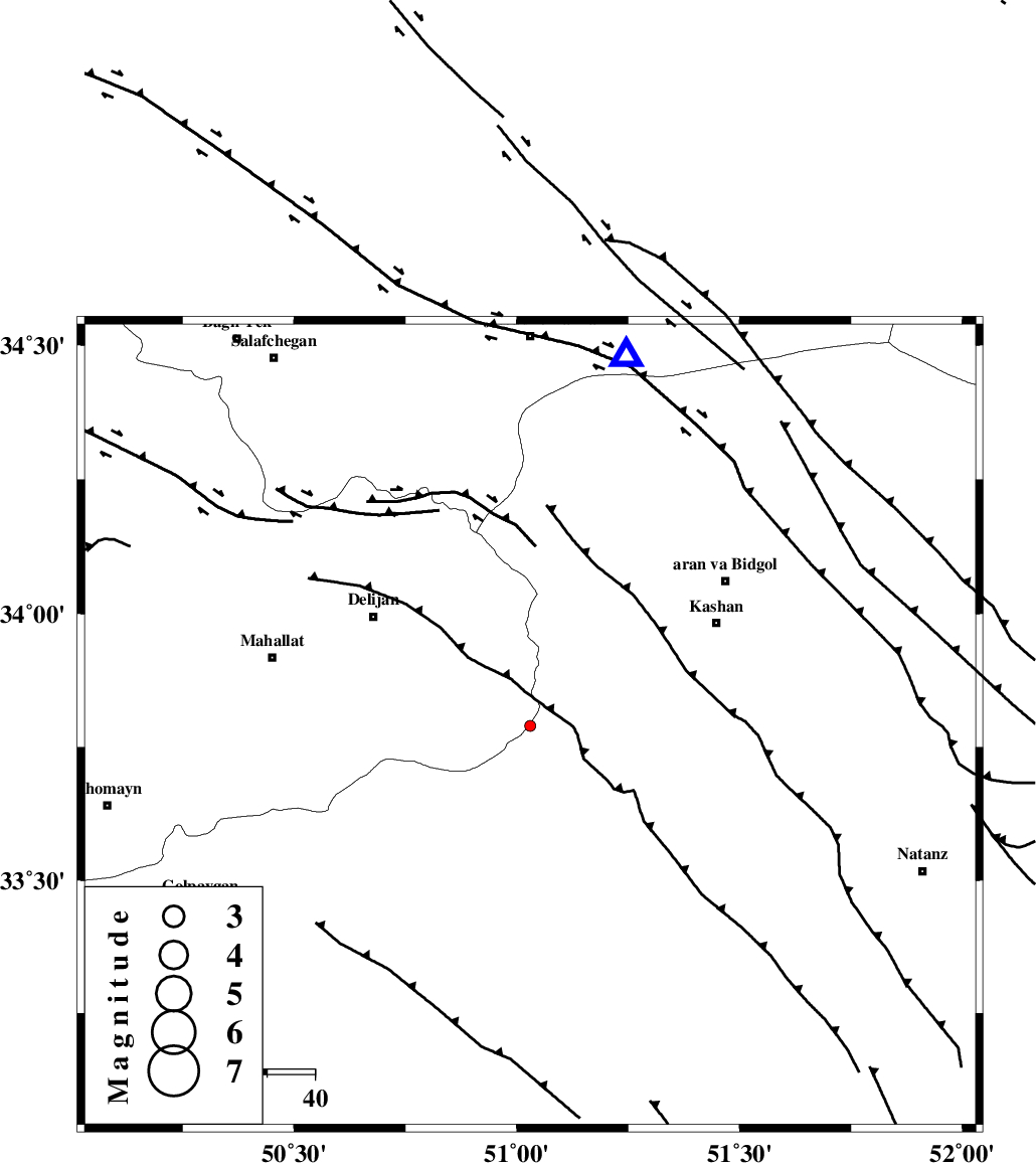
| Location | Lat:33.79 Lon: 51.03 |
| Region | Esfahan Province, 39 km South-East of Delijan |
Nearest Cities |
|
| 18 km West of Barzak, Esfahan Province | |
| 22 km South West of Niyasar, Esfahan Province | |
| 25 km East of Hastijan, Markazi Province | |
| 28 km North West of Joshqan qali, Esfahan Province | |
| 30 km South East of Naraq, Markazi Province | |
| Depth | 14 km |
| Agency | |
Faults within 150 km: |
|
| KASHAN_F (Length: 44 km) , Distance to epicenter: 39 km | |
| ZEFREH_F (Length: 124 km) , Distance to epicenter: 45 km | |
| TAFRESH_F (Length: 117 km) , Distance to epicenter: 72 km | |
| Number of Phases | 8 |
| RMS | 0.1 |
| Number of Stations | 5 |
| Error in Latitude | >2 km |
| Error in Longitude | 2.1 km |
| Error in Depth | 8.9 km |
Download waveform in seisan format
to download seisan software Click here
to access information about IIEES stations Click here
Amplitude | ||||||||
| UID | Agency | Station | Component | Amplitude | Period | Arrival Time | Proccessing Time | Signal Clip |
| 95580 | IIEES | GHVR | E | 29.6 | 0.39 | 2015-05-05 08:27:43 | 2015-05-05 11:02:00 | n |
| 95581 | IIEES | GHVR | N | 26.8 | 0.36 | 2015-05-05 08:27:44 | 2015-05-05 11:02:00 | n |
Phase | ||||||||||||
| Agency | Station | Component | Phase Type | Phase Quality | First Motion | Observed Arrival Time | Time Residual | Loc. Flag | Input Weight | Distance | Azimuth | |
| IIEES | GHVR | Z | Pg | E | 2015-05-05 08:27:32 | 0.01 | y | 79.2 | 15 | |||
| IIEES | GHVR | E | Sg | E | 2015-05-05 08:27:42 | 0.06 | y | 79.2 | 15 | |||
| IIEES | KHMZ | Z | Pg | E | 2015-05-05 08:27:35 | -0.16 | y | 98.6 | 267 | |||
| IIEES | ASAO | Z | Pg | E | 2015-05-05 08:27:39 | 0.17 | y | 125 | 313 | |||
| IIEES | ASAO | E | Sg | E | 2015-05-05 08:27:55 | 0.08 | y | 125 | 313 | |||
| IIEES | CHTH | Z | Pg | E | 2015-05-05 08:27:56 | -0.07 | y | 235 | 2 | |||
| IIEES | CHTH | E | Sg | E | 2015-05-05 08:28:25 | -0.13 | y | 235 | 2 | |||
| IIEES | BSRN | Z | Pn | E | 2015-05-05 08:29:03 | 0.11 | y | 784 | 103 | |||