
Magnitude |
:3.1 |
| Date & Time (UTC) | 2015-04-26 05:18:15.4 |
| Date & Time (Local) | 1394/2/6 09:48:15.4 |
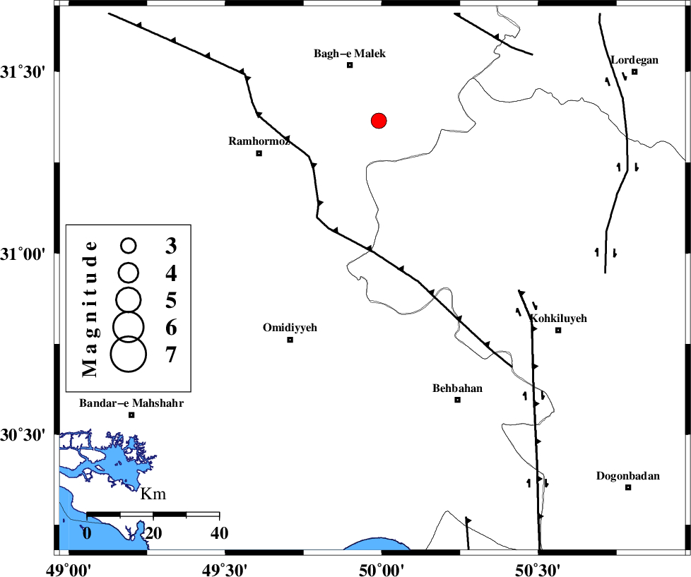
| Location | Lat:30.93 Lon: 49.97 |
| Region | Kohkiluieh va boyerahmad Province, 32 km North-East of Omidiyeh |
Nearest Cities |
|
| 13 km North East of Jayzan, Khoozestan Province | |
| 14 km North of Jolaki, Khoozestan Province | |
| 29 km North East of Aghajari, Khoozestan Province | |
| 29 km South East of Soltanabad, Khoozestan Province | |
| 31 km North East of Omidiyeh, Khoozestan Province | |
| Depth | 14 km |
| Agency | |
Faults within 150 km: |
|
| MFF4 (Length: 62 km) , Distance to epicenter: 18 km | |
| AGHAJARI_F (Length: 88 km) , Distance to epicenter: 31 km | |
| DEZFUL_EMBAYMENT (Length: 228 km) , Distance to epicenter: 38 km | |
| Number of Phases | 6 |
| RMS | 0.2 |
| Number of Stations | 5 |
| Error in Latitude | >2.7 km |
| Error in Longitude | 6.1 km |
| Error in Depth | 8 km |
Download waveform in seisan format
to download seisan software Click here
to access information about IIEES stations Click here
Amplitude | ||||||||
| UID | Agency | Station | Component | Amplitude | Period | Arrival Time | Proccessing Time | Signal Clip |
| 95519 | IIEES | AHRM | N | 106.3 | 0.77 | 2015-04-26 05:19:49 | 2015-04-26 07:04:00 | n |
| 95520 | IIEES | YZKH | N | 17.5 | 0.38 | 2015-04-26 05:20:15 | 2015-04-26 07:04:00 | n |
Phase | ||||||||||||
| Agency | Station | Component | Phase Type | Phase Quality | First Motion | Observed Arrival Time | Time Residual | Loc. Flag | Input Weight | Distance | Azimuth | |
| IIEES | AHRM | Z | Pn | E | 2015-04-26 05:18:55 | -0.14 | y | 262 | 150 | |||
| IIEES | KHMZ | Z | Pn | E | 2015-04-26 05:19:02 | 0.25 | y | 311 | 360 | |||
| IIEES | NASN | Z | Pn | E | 2015-04-26 05:19:05 | -0.03 | y | 339 | 52 | |||
| IIEES | ASAO | Z | Pn | E | 2015-04-26 05:19:13 | 0 | y | 401 | 1 | |||
| IIEES | ASAO | E | Sg | E | 2015-04-26 05:20:07 | -0.21 | y | 401 | 1 | |||
| IIEES | YZKH | Z | Pn | E | 2015-04-26 05:19:21 | 0.14 | y | 467 | 69 | |||