
Magnitude |
:4 |
| Date & Time (UTC) | 2015-04-26 01:05:27.9 |
| Date & Time (Local) | 1394/2/6 05:35:27.9 |
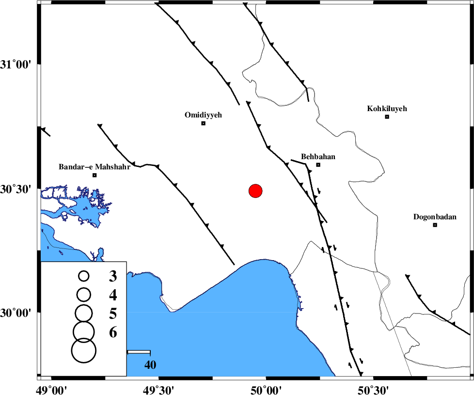
| Location | Lat:30.49 Lon: 49.95 |
| Region | Khoozestan Province, 30 km South-West of Behbahan |
Nearest Cities |
|
| 18 km North West of Darunak, Khoozestan Province | |
| 19 km East of Asiyab, Khoozestan Province | |
| 26 km South East of Aghajari, Khoozestan Province | |
| 26 km North East of Chamkhalf-e eisa, Khoozestan Province | |
| 30 km South West of Behbahan, Khoozestan Province | |
| Depth | 14 km |
| Agency | |
Faults within 150 km: |
|
| RAG_E_SEFID_F (Length: 84 km) , Distance to epicenter: 16 km | |
| AGHAJARI_F (Length: 88 km) , Distance to epicenter: 17 km | |
| MFF4 (Length: 62 km) , Distance to epicenter: 48 km | |
| Number of Phases | 6 |
| RMS | 0.1 |
| Number of Stations | 5 |
| Error in Latitude | >2.7 km |
| Error in Longitude | 6.3 km |
| Error in Depth | 7.4 km |
Download waveform in seisan format
to download seisan software Click here
to access information about IIEES stations Click here
Amplitude | ||||||||
| UID | Agency | Station | Component | Amplitude | Period | Arrival Time | Proccessing Time | Signal Clip |
| 95516 | IIEES | KRBR | N | 47.1 | 0.44 | 2015-04-26 01:08:15 | 2015-04-26 01:31:00 | n |
| 95517 | IIEES | KRBR | E | 55 | 0.4 | 2015-04-26 01:08:18 | 2015-04-26 01:31:00 | n |
Phase | ||||||||||||
| Agency | Station | Component | Phase Type | Phase Quality | First Motion | Observed Arrival Time | Time Residual | Loc. Flag | Input Weight | Distance | Azimuth | |
| IIEES | AHRM | Z | Pn | E | 2015-04-26 01:06:03 | 0.04 | y | 223 | 144 | |||
| IIEES | AHRM | N | Sg | E | 2015-04-26 01:06:30 | -0.06 | y | 223 | 144 | |||
| IIEES | KHMZ | Z | Pn | E | 2015-04-26 01:06:20 | -0.16 | y | 360 | 0 | |||
| IIEES | NASN | Z | Pn | E | 2015-04-26 01:06:22 | -0.07 | y | 373 | 46 | |||
| IIEES | ASAO | Z | Pn | E | 2015-04-26 01:06:31 | 0.16 | y | 450 | 1 | |||
| IIEES | KRBR | Z | Pn | E | 2015-04-26 01:06:57 | 0.19 | y | 658 | 93 | |||