
Magnitude |
:3.7 |
| Date & Time (UTC) | 2015-04-25 02:41:12.9 |
| Date & Time (Local) | 1394/2/5 07:11:12.9 |
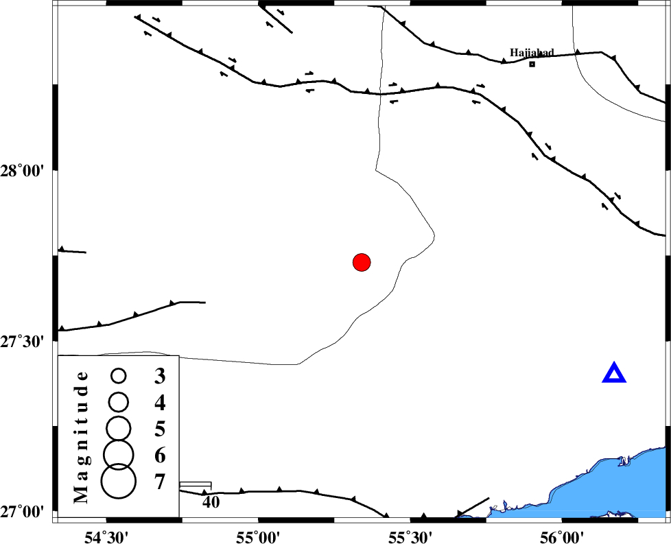
| Location | Lat:27.73 Lon: 55.34 |
| Region | Fars Province, 99 km East of Lar |
Nearest Cities |
|
| 17 km South of Darz, Fars Province | |
| 55 km South East of Fadami, Fars Province | |
| 56 km North West of Fin, Hormozgan Province | |
| 66 km South East of Doborji, Fars Province | |
| 84 km South East of Rostaq, Fars Province | |
| Depth | 15 km |
| Agency | |
Faults within 150 km: |
|
| LAR_F (Length: 99 km) , Distance to epicenter: 52 km | |
| HZF2 (Length: 437 km) , Distance to epicenter: 55 km | |
| MAIN_ZAGROS_R_F (Length: 1106 km) , Distance to epicenter: 74 km | |
| Number of Phases | 7 |
| RMS | 0.4 |
| Number of Stations | 7 |
| Error in Latitude | >7.5 km |
| Error in Longitude | 3.4 km |
| Error in Depth | 0 km |
Download waveform in seisan format
to download seisan software Click here
to access information about IIEES stations Click here
Amplitude | ||||||||
| UID | Agency | Station | Component | Amplitude | Period | Arrival Time | Proccessing Time | Signal Clip |
| 95515 | IIEES | KRBR | E | 355.4 | 0.57 | 2015-04-25 02:42:36 | 2015-04-25 03:06:00 | n |
Phase | ||||||||||||
| Agency | Station | Component | Phase Type | Phase Quality | First Motion | Observed Arrival Time | Time Residual | Loc. Flag | Input Weight | Distance | Azimuth | |
| IIEES | KRBR | Z | Pn | E | 2015-04-25 02:41:56 | -0.04 | y | 286 | 29 | |||
| IIEES | YZKH | Z | Pn | E | 2015-04-25 02:42:25 | 0.08 | y | 522 | 352 | |||
| IIEES | CHBR | Z | Pn | E | 2015-04-25 02:42:30 | -0.13 | y | 564 | 114 | |||
| IIEES | ZHSF | Z | Pn | E | 2015-04-25 02:42:32 | 0.45 | y | 571 | 67 | |||
| IIEES | BSRN | Z | Pn | E | 2015-04-25 02:42:33 | -0.75 | y | 595 | 37 | |||
| IIEES | NASN | Z | Pn | E | 2015-04-25 02:42:37 | 0.04 | y | 613 | 337 | |||
| IIEES | SHRT | Z | Pn | E | 2015-04-25 02:43:01 | 0.58 | y | 810 | 35 | |||