
Magnitude |
:3.3 |
| Date & Time (UTC) | 2015-04-24 22:55:46.3 |
| Date & Time (Local) | 1394/2/5 03:25:46.3 |
| Location | Lat:30.69 Lon: 49.73 |
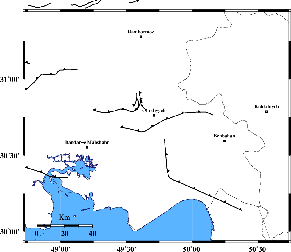
| Region | Khoozestan Province, 8 km Omidiyeh |
Nearest Cities |
|
| 4 km of Chah-e salem, Khoozestan Province | |
| 8 km of Omidiyeh, Khoozestan Province | |
| 10 km West of Aghajari, Khoozestan Province | |
| 12 km North of Asiyab, Khoozestan Province | |
| 22 km South West of Jolaki, Khoozestan Province | |
| Depth | 15 km |
| Agency | |
Faults within 150 km: |
|
| RAG_E_SEFID_F (Length: 84 km) , Distance to epicenter: 11 km | |
| AGHAJARI_F (Length: 88 km) , Distance to epicenter: 15 km | |
| MFF4 (Length: 62 km) , Distance to epicenter: 52 km | |
| Number of Phases | 5 |
| RMS | 0.1 |
| Number of Stations | 5 |
| Error in Latitude | >2.5 km |
| Error in Longitude | 2.1 km |
| Error in Depth | 0 km |
Download waveform in seisan format
to download seisan software Click here
to access information about IIEES stations Click here
Amplitude | ||||||||
| UID | Agency | Station | Component | Amplitude | Period | Arrival Time | Proccessing Time | Signal Clip |
| 95514 | IIEES | ASAO | N | 40.9 | 0.48 | 2015-04-24 22:57:42 | 2015-04-25 02:21:00 | n |
Phase | ||||||||||||
| Agency | Station | Component | Phase Type | Phase Quality | First Motion | Observed Arrival Time | Time Residual | Loc. Flag | Input Weight | Distance | Azimuth | |
| IIEES | AHRM | Z | Pn | E | 2015-04-24 22:56:25 | 0.01 | y | 253 | 143 | |||
| IIEES | KHMZ | Z | Pn | E | 2015-04-24 22:56:36 | -0.13 | y | 339 | 4 | |||
| IIEES | ASAO | Z | Pn | E | 2015-04-24 22:56:47 | 0.25 | y | 429 | 4 | |||
| IIEES | YZKH | Z | Pn | E | 2015-04-24 22:56:56 | -0.06 | y | 499 | 67 | |||
| IIEES | SNGE | Z | Pn | E | 2015-04-24 22:57:00 | -0.08 | y | 537 | 336 | |||