
Magnitude |
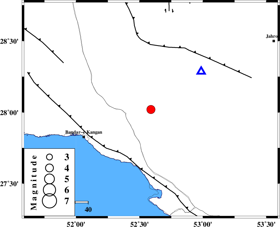
:4.3 |
| Date & Time (UTC) | 2015-04-20 16:04:29.0 |
| Date & Time (Local) | 1394/1/31 20:34:29.0 |
| Location | Lat:28.02 Lon: 52.59 |
| Region | Fars Province, 34 km North-East of Jam |
Nearest Cities |
|
| 14 km North West of Garmesht, Fars Province | |
| 33 km South East of Dolatabad, Fars Province | |
| 33 km North of Asir, Fars Province | |
| 34 km North East of Jam, Bushehr Province | |
| 39 km South of Hengam, Fars Province | |
| Depth | 17 km |
| Agency | |
Faults within 150 km: |
|
| MFF3 (Length: 292 km) , Distance to epicenter: 41 km | |
| QIR_F (Length: 130 km) , Distance to epicenter: 50 km | |
| MFF5 (Length: 74 km) , Distance to epicenter: 77 km | |
| Number of Phases | 6 |
| RMS | 0.1 |
| Number of Stations | 5 |
| Error in Latitude | >4 km |
| Error in Longitude | 2.4 km |
| Error in Depth | 6.2 km |
Download waveform in seisan format
to download seisan software Click here
to access information about IIEES stations Click here
Amplitude | ||||||||
| UID | Agency | Station | Component | Amplitude | Period | Arrival Time | Proccessing Time | Signal Clip |
| 95479 | IIEES | AHRM | E | 2563.7 | 0.52 | 2015-04-20 16:05:20 | 2015-04-20 04:27:00 | n |
| 95480 | IIEES | AHRM | N | 5604.3 | 0.48 | 2015-04-20 16:05:24 | 2015-04-20 04:27:00 | n |
| 95481 | IIEES | SHGR | N | 168.6 | 0.6 | 2015-04-20 16:07:00 | 2015-04-20 04:27:00 | n |
Phase | ||||||||||||
| Agency | Station | Component | Phase Type | Phase Quality | First Motion | Observed Arrival Time | Time Residual | Loc. Flag | Input Weight | Distance | Azimuth | |
| IIEES | AHRM | Z | Pg | E | 2015-04-20 16:04:55 | 0.11 | y | 158 | 307 | |||
| IIEES | AHRM | N | Sg | E | 2015-04-20 16:05:13 | -0.11 | y | 158 | 307 | |||
| IIEES | KRBR | Z | Pn | E | 2015-04-20 16:05:33 | -0.18 | y | 461 | 61 | |||
| IIEES | YZKH | Z | Pn | E | 2015-04-20 16:05:41 | 0.14 | y | 521 | 21 | |||
| IIEES | YZKH | N | Sg | E | 2015-04-20 16:06:54 | 0 | y | 521 | 21 | |||
| IIEES | NASN | Z | Pn | E | 2015-04-20 16:05:42 | 0.05 | y | 530 | 2 | |||