
Magnitude |
:3.7 |
| Date & Time (UTC) | 2015-04-20 05:52:56.2 |
| Date & Time (Local) | 1394/1/31 10:22:56.2 |
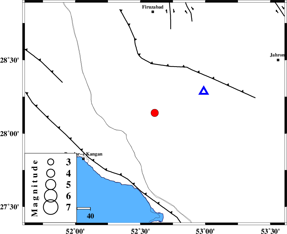
| Location | Lat:28.14 Lon: 52.61 |
| Region | Fars Province, 45 km North-East of Jam |
Nearest Cities |
|
| 19 km North West of Garmesht, Fars Province | |
| 26 km South of Hengam, Fars Province | |
| 31 km East of Dolatabad, Fars Province | |
| 45 km North East of Jam, Bushehr Province | |
| 46 km North of Asir, Fars Province | |
| Depth | 18 km |
| Agency | |
Faults within 150 km: |
|
| QIR_F (Length: 130 km) , Distance to epicenter: 37 km | |
| MFF3 (Length: 292 km) , Distance to epicenter: 54 km | |
| SABZ_PUSHAN_F_Z1 (Length: 69 km) , Distance to epicenter: 64 km | |
| Number of Phases | 6 |
| RMS | 0.1 |
| Number of Stations | 5 |
| Error in Latitude | >7.8 km |
| Error in Longitude | 3.8 km |
| Error in Depth | 6 km |
Download waveform in seisan format
to download seisan software Click here
to access information about IIEES stations Click here
Amplitude | ||||||||
| UID | Agency | Station | Component | Amplitude | Period | Arrival Time | Proccessing Time | Signal Clip |
| 95473 | IIEES | AHRM | N | 1153.2 | 0.52 | 2015-04-20 05:53:43 | 2015-04-20 06:17:00 | n |
| 95474 | IIEES | AHRM | E | 1021.1 | 0.7 | 2015-04-20 05:53:51 | 2015-04-20 06:17:00 | n |
Phase | ||||||||||||
| Agency | Station | Component | Phase Type | Phase Quality | First Motion | Observed Arrival Time | Time Residual | Loc. Flag | Input Weight | Distance | Azimuth | |
| IIEES | AHRM | Z | Pg | E | 2015-04-20 05:53:21 | -0.05 | y | 151 | 302 | |||
| IIEES | AHRM | N | Sg | E | 2015-04-20 05:53:39 | 0.06 | y | 151 | 302 | |||
| IIEES | KRBR | Z | Pn | E | 2015-04-20 05:54:00 | 0.09 | y | 453 | 62 | |||
| IIEES | YZKH | Z | Pn | E | 2015-04-20 05:54:06 | -0.05 | y | 508 | 22 | |||
| IIEES | SHGR | Z | P | E | 2015-04-20 05:54:14 | -0.03 | y | 573 | 321 | |||
| IIEES | KHMZ | Z | P | E | 2015-04-20 05:54:26 | -0.03 | y | 670 | 339 | |||