
Magnitude |
:2.7 |
| Date & Time (UTC) | 2015-04-20 02:26:39.1 |
| Date & Time (Local) | 1394/1/31 06:56:39.1 |
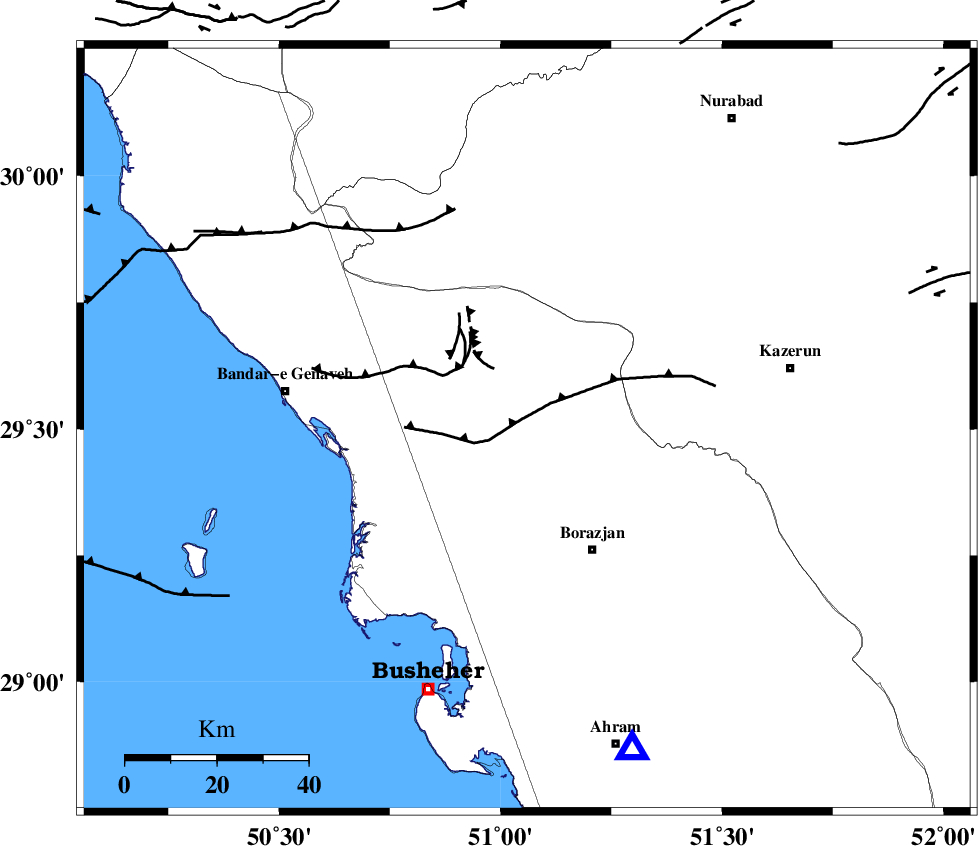
| Location | Lat:29.5 Lon: 51.06 |
| Region | Bushehr Province, 30 km North-West of Borazjan |
Nearest Cities |
|
| 7 km North of Dehkohneh, Bushehr Province | |
| 15 km North of Saedabad, Bushehr Province | |
| 19 km North West of Nazar aqa, Bushehr Province | |
| 24 km North West of Dalki, Bushehr Province | |
| 24 km North of Ziyarat, Bushehr Province | |
| Depth | 6 km |
| Agency | |
Faults within 150 km: |
|
| ZFF3 (Length: 125 km) , Distance to epicenter: 5 km | |
| BORAZJAN_F (Length: 168 km) , Distance to epicenter: 19 km | |
| KAZERUN_F (Length: 96 km) , Distance to epicenter: 46 km | |
| Number of Phases | 6 |
| RMS | 0.1 |
| Number of Stations | 6 |
| Error in Latitude | >3.7 km |
| Error in Longitude | 5.5 km |
| Error in Depth | 9.9 km |
Download waveform in seisan format
to download seisan software Click here
to access information about IIEES stations Click here
Amplitude | ||||||||
| UID | Agency | Station | Component | Amplitude | Period | Arrival Time | Proccessing Time | Signal Clip |
| 95471 | IIEES | AHRM | E | 279.9 | 0.34 | 2015-04-20 02:27:07 | 2015-04-20 05:25:00 | n |
| 95472 | IIEES | KRBR | N | 6.2 | 0.67 | 2015-04-20 02:29:05 | 2015-04-20 05:25:00 | n |
Phase | ||||||||||||
| Agency | Station | Component | Phase Type | Phase Quality | First Motion | Observed Arrival Time | Time Residual | Loc. Flag | Input Weight | Distance | Azimuth | |
| IIEES | AHRM | Z | P | E | 2015-04-20 02:26:52 | -0.05 | y | 74.4 | 162 | |||
| IIEES | AHRM | E | Sg | E | 2015-04-20 02:27:03 | 0.02 | y | 74.4 | 162 | |||
| IIEES | NASN | Z | Pn | E | 2015-04-20 02:27:37 | -0.13 | y | 402 | 24 | |||
| IIEES | YZKH | Z | Pn | E | 2015-04-20 02:27:45 | 0.1 | y | 465 | 46 | |||
| IIEES | KHMZ | Z | Pn | E | 2015-04-20 02:27:47 | -0.1 | y | 481 | 348 | |||
| IIEES | ASAO | Z | Pn | E | 2015-04-20 02:27:58 | 0.21 | y | 568 | 350 | |||