
Magnitude |
:3 |
| Date & Time (UTC) | 2015-04-18 23:23:23.2 |
| Date & Time (Local) | 1394/1/30 03:53:23.2 |
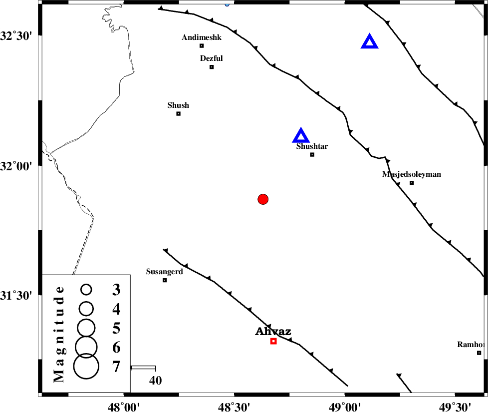
| Location | Lat:31.87 Lon: 48.63 |
| Region | Khoozestan Province, 29 km South-West of Shushtar |
Nearest Cities |
|
| 22 km West of Mehdiabad, Khoozestan Province | |
| 22 km South West of Sardarabad, Khoozestan Province | |
| 24 km North East of Abdolkhan-eali, Khoozestan Province | |
| 25 km North West of Arabhasan, Khoozestan Province | |
| 28 km South West of Shushtar, Khoozestan Province | |
| Depth | 14 km |
| Agency | |
Faults within 150 km: |
|
| AHVAZ_F (Length: 99 km) , Distance to epicenter: 41 km | |
| DEZFUL_EMBAYMENT (Length: 228 km) , Distance to epicenter: 46 km | |
| MFF2 (Length: 205 km) , Distance to epicenter: 86 km | |
| Number of Phases | 6 |
| RMS | 0.2 |
| Number of Stations | 4 |
| Error in Latitude | >5.2 km |
| Error in Longitude | 9.1 km |
| Error in Depth | 7 km |
Download waveform in seisan format
to download seisan software Click here
to access information about IIEES stations Click here
Amplitude | ||||||||
| UID | Agency | Station | Component | Amplitude | Period | Arrival Time | Proccessing Time | Signal Clip |
| 95455 | IIEES | SHGR | N | 3891.2 | 0.32 | 2015-04-18 23:23:33 | 2015-04-18 11:41:00 | n |
| 95456 | IIEES | SHGR | E | 3399.9 | 0.4 | 2015-04-18 23:23:34 | 2015-04-18 11:41:00 | n |
| 95457 | IIEES | ASAO | E | 20.8 | 0.52 | 2015-04-18 23:25:03 | 2015-04-18 11:41:00 | n |
Phase | ||||||||||||
| Agency | Station | Component | Phase Type | Phase Quality | First Motion | Observed Arrival Time | Time Residual | Loc. Flag | Input Weight | Distance | Azimuth | |
| IIEES | SHGR | Z | Pg | E | 2015-04-18 23:23:29 | -0.18 | y | 31.1 | 32 | |||
| IIEES | SHGR | E | Sg | E | 2015-04-18 23:23:33 | -0.16 | y | 31.1 | 32 | |||
| IIEES | KHMZ | Z | Pg | E | 2015-04-18 23:24:03 | 0.21 | y | 242 | 31 | |||
| IIEES | ASAO | Z | Pn | E | 2015-04-18 23:24:11 | 0.08 | y | 324 | 23 | |||
| IIEES | ASAO | N | Sg | E | 2015-04-18 23:24:54 | 0.14 | y | 324 | 23 | |||
| IIEES | SNGE | Z | Pn | E | 2015-04-18 23:24:17 | -0.09 | y | 377 | 342 | |||