
Magnitude |
:3.3 |
| Date & Time (UTC) | 2015-04-18 23:04:55.3 |
| Date & Time (Local) | 1394/1/30 03:34:55.3 |
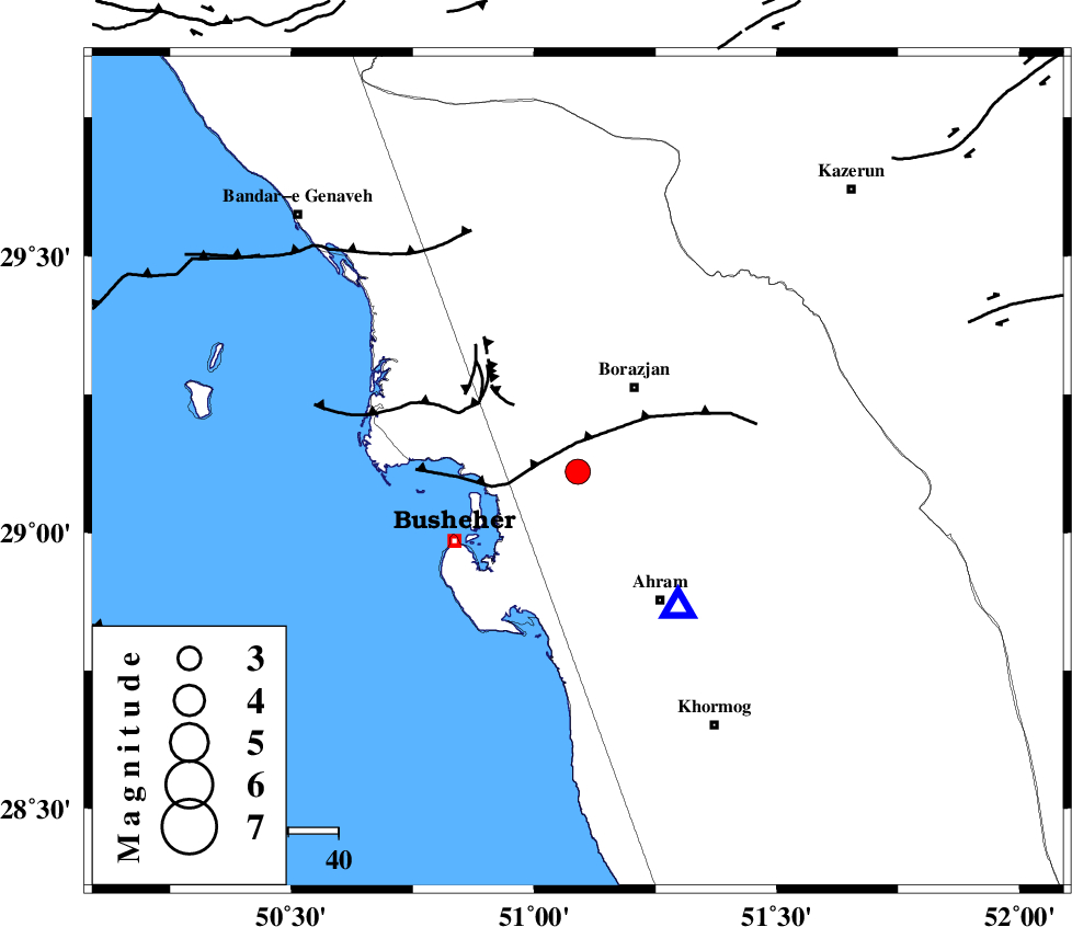
| Location | Lat:29.11 Lon: 51.09 |
| Region | Bushehr Province, 20 km South-West of Borazjan |
Nearest Cities |
|
| 15 km West of Sarkareh, Bushehr Province | |
| 15 km North of Choghadak, Bushehr Province | |
| 19 km South of Ziyarat, Bushehr Province | |
| 20 km South West of Borazjan, Bushehr Province | |
| 24 km South East of Shabankareh, Bushehr Province | |
| Depth | 14 km |
| Agency | |
Faults within 150 km: |
|
| BORAZJAN_F (Length: 168 km) , Distance to epicenter: 22 km | |
| ZFF2 (Length: 84 km) , Distance to epicenter: 23 km | |
| ZFF3 (Length: 125 km) , Distance to epicenter: 27 km | |
| Number of Phases | 4 |
| RMS | 0.1 |
| Number of Stations | 3 |
| Error in Latitude | >3.9 km |
| Error in Longitude | 5.7 km |
| Error in Depth | 5.7 km |
Download waveform in seisan format
to download seisan software Click here
to access information about IIEES stations Click here
Amplitude | ||||||||
| UID | Agency | Station | Component | Amplitude | Period | Arrival Time | Proccessing Time | Signal Clip |
| 95452 | IIEES | AHRM | E | 4807.3 | 0.56 | 2015-04-18 23:05:11 | 2015-04-18 11:33:00 | n |
| 95453 | IIEES | AHRM | N | 3939 | 0.48 | 2015-04-18 23:05:12 | 2015-04-18 11:33:00 | n |
| 95454 | IIEES | SHGR | N | 41.4 | 0.36 | 2015-04-18 23:06:49 | 2015-04-18 11:33:00 | n |
Phase | ||||||||||||
| Agency | Station | Component | Phase Type | Phase Quality | First Motion | Observed Arrival Time | Time Residual | Loc. Flag | Input Weight | Distance | Azimuth | |
| IIEES | AHRM | Z | Pg | E | 2015-04-18 23:05:01 | -0.03 | y | 34 | 144 | |||
| IIEES | SHGR | Z | Pn | E | 2015-04-18 23:05:52 | 0.21 | y | 398 | 327 | |||
| IIEES | SHGR | E | Sg | E | 2015-04-18 23:06:46 | -0.13 | y | 398 | 327 | |||
| IIEES | YZKH | Z | Pn | E | 2015-04-18 23:06:04 | -0.04 | y | 494 | 42 | |||