
Magnitude |
:3.2 |
| Date & Time (UTC) | 2015-04-17 03:59:19.9 |
| Date & Time (Local) | 1394/1/28 08:29:19.9 |
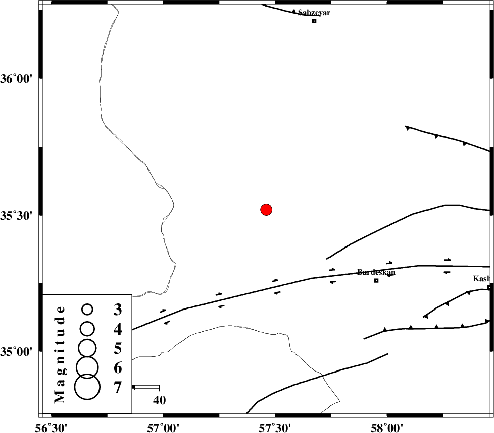
| Location | Lat:35.52 Lon: 57.46 |
| Region | Khorasan(center) Province, 53 km North-West of Bardeskan |
Nearest Cities |
|
| 34 km South West of Bejdan, Khorasan(center) Province | |
| 43 km South West of Tondak, Khorasan(center) Province | |
| 49 km North West of Kabudan, Khorasan(center) Province | |
| 53 km North West of Bardeskan, Khorasan(center) Province | |
| 56 km South West of Sheshtamad, Khorasan(center) Province | |
| Depth | 18 km |
| Agency | |
Faults within 150 km: |
|
| BIJVARD_F (Length: 83 km) , Distance to epicenter: 32 km | |
| DORUNEH_F (Length: 713 km) , Distance to epicenter: 32 km | |
| BALHAR_F (Length: 117 km) , Distance to epicenter: 66 km | |
| Number of Phases | 4 |
| RMS | 0.1 |
| Number of Stations | 3 |
| Error in Latitude | >2.2 km |
| Error in Longitude | 4.3 km |
| Error in Depth | 7.3 km |
Download waveform in seisan format
to download seisan software Click here
to access information about IIEES stations Click here
Amplitude | ||||||||
| UID | Agency | Station | Component | Amplitude | Period | Arrival Time | Proccessing Time | Signal Clip |
| 95446 | IIEES | YZKH | N | 33.1 | 0.48 | 2015-04-17 04:01:32 | 2015-04-17 05:01:00 | n |
| 95447 | IIEES | YZKH | E | 34.8 | 0.64 | 2015-04-17 04:01:36 | 2015-04-17 05:01:00 | n |
Phase | ||||||||||||
| Agency | Station | Component | Phase Type | Phase Quality | First Motion | Observed Arrival Time | Time Residual | Loc. Flag | Input Weight | Distance | Azimuth | |
| IIEES | SHRO | Z | Pg | E | 2015-04-17 03:59:43 | 0.03 | y | 142 | 293 | |||
| IIEES | SHRT | Z | Pn | E | 2015-04-17 04:00:08 | 0.04 | y | 332 | 128 | |||
| IIEES | YZKH | Z | Pn | E | 2015-04-17 04:00:21 | -0.15 | y | 437 | 218 | |||
| IIEES | YZKH | N | Sg | E | 2015-04-17 04:01:22 | 0.06 | y | 437 | 218 | |||