
Magnitude |
:3.3 |
| Date & Time (UTC) | 2015-04-05 01:21:40.9 |
| Date & Time (Local) | 1394/1/16 05:51:40.9 |
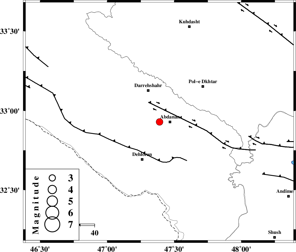
| Location | Lat:32.93 Lon: 47.39 |
| Region | Ilam Province, 7 km Abdanan |
Nearest Cities |
|
| 7 km of Abdanan, Ilam Province | |
| 17 km North West of Sarabbagh, Ilam Province | |
| 23 km South of Darreh Shahr, Ilam Province | |
| 27 km South of Dashtabad-e olia, Ilam Province | |
| 29 km North East of Dehloran, Ilam Province | |
| Depth | 14 km |
| Agency | |
Faults within 150 km: |
|
| BALARUD_F_Z1 (Length: 87 km) , Distance to epicenter: 16 km | |
| MFF6 (Length: 144 km) , Distance to epicenter: 25 km | |
| BALARUD_F_Z3 (Length: 53 km) , Distance to epicenter: 63 km | |
| Number of Phases | 5 |
| RMS | 0.1 |
| Number of Stations | 3 |
| Error in Latitude | >1.7 km |
| Error in Longitude | 6.4 km |
| Error in Depth | 6.3 km |
Download waveform in seisan format
to download seisan software Click here
to access information about IIEES stations Click here
Amplitude | ||||||||
| UID | Agency | Station | Component | Amplitude | Period | Arrival Time | Proccessing Time | Signal Clip |
| 95327 | IIEES | SHGR | E | 426.5 | 0.48 | 2015-04-05 01:22:30 | 2015-04-05 01:50:00 | n |
| 95328 | IIEES | SHGR | N | 700.4 | 0.68 | 2015-04-05 01:22:30 | 2015-04-05 01:50:00 | n |
| 95329 | IIEES | ASAO | N | 92.9 | 0.64 | 2015-04-05 01:23:18 | 2015-04-05 01:50:00 | n |
Phase | ||||||||||||
| Agency | Station | Component | Phase Type | Phase Quality | First Motion | Observed Arrival Time | Time Residual | Loc. Flag | Input Weight | Distance | Azimuth | |
| IIEES | SHGR | Z | Pg | E | 2015-04-05 01:22:07 | -0.16 | y | 161 | 124 | |||
| IIEES | SHGR | N | Sg | E | 2015-04-05 01:22:26 | 0.08 | y | 161 | 124 | |||
| IIEES | KHMZ | Z | Pn | E | 2015-04-05 01:22:20 | 0.12 | y | 256 | 69 | |||
| IIEES | ASAO | Z | Pn | E | 2015-04-05 01:22:26 | 0.02 | y | 303 | 53 | |||
| IIEES | ASAO | E | Sg | E | 2015-04-05 01:23:06 | -0.06 | y | 303 | 53 | |||