
Magnitude |
:3.2 |
| Date & Time (UTC) | 2015-04-03 11:58:17.0 |
| Date & Time (Local) | 1394/1/14 16:28:17.0 |
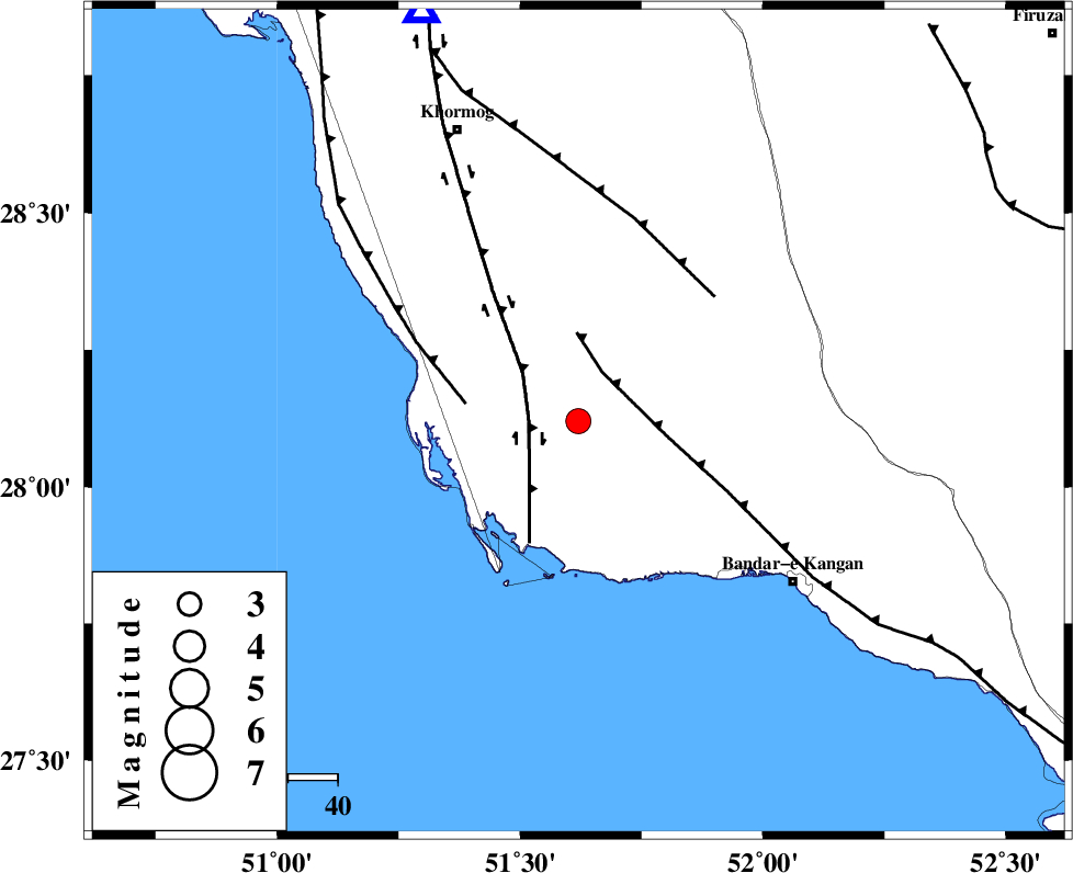
| Location | Lat:28.12 Lon: 51.62 |
| Region | Bushehr Province, 54 km North-West of Bandar-e kangan |
Nearest Cities |
|
| 11 km of Abkesh, Bushehr Province | |
| 15 km North West of Abdan, Bushehr Province | |
| 16 km North East of Bardkhun, Bushehr Province | |
| 25 km East of Ziyarat, Bushehr Province | |
| 26 km South East of Kaki, Bushehr Province | |
| Depth | 32 km |
| Agency | |
Faults within 150 km: |
|
| BORAZJAN_F (Length: 168 km) , Distance to epicenter: 10 km | |
| MFF3 (Length: 292 km) , Distance to epicenter: 11 km | |
| ZFF2 (Length: 84 km) , Distance to epicenter: 23 km | |
| Number of Phases | 4 |
| RMS | 0 |
| Number of Stations | 3 |
| Error in Latitude | >6.8 km |
| Error in Longitude | 17.3 km |
| Error in Depth | 14.6 km |
Download waveform in seisan format
to download seisan software Click here
to access information about IIEES stations Click here
Amplitude | ||||||||
| UID | Agency | Station | Component | Amplitude | Period | Arrival Time | Proccessing Time | Signal Clip |
| 95317 | IIEES | AHRM | E | 732.3 | 0.48 | 2015-04-03 11:58:51 | 2015-04-03 01:22:00 | n |
| 95318 | IIEES | AHRM | N | 826 | 0.44 | 2015-04-03 11:58:56 | 2015-04-03 01:22:00 | n |
Phase | ||||||||||||
| Agency | Station | Component | Phase Type | Phase Quality | First Motion | Observed Arrival Time | Time Residual | Loc. Flag | Input Weight | Distance | Azimuth | |
| IIEES | AHRM | Z | Pg | E | 2015-04-03 11:58:32 | 0 | y | 88.8 | 339 | |||
| IIEES | AHRM | N | Sg | E | 2015-04-03 11:58:43 | 0 | y | 88.8 | 339 | |||
| IIEES | KRBR | Z | Pn | E | 2015-04-03 11:59:30 | 0.01 | y | 541 | 66 | |||
| IIEES | YZKH | Z | Pn | E | 2015-04-03 11:59:31 | 0 | y | 553 | 30 | |||