
Magnitude |
:2.3 |
| Date & Time (UTC) | 2015-04-01 03:18:50.3 |
| Date & Time (Local) | 1394/1/12 07:48:50.3 |
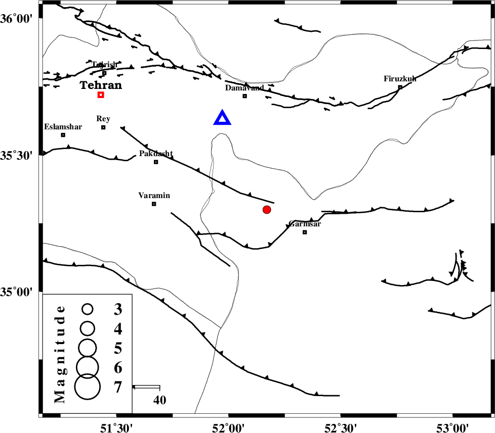
| Location | Lat:35.3 Lon: 52.17 |
| Region | Semnan Province, 18 km West of Garmsar |
Nearest Cities |
|
| 11 km East of Evanekay, Semnan Province | |
| 17 km North East of Cheshmeh nadi, Semnan Province | |
| 18 km North West of Garmsar, Semnan Province | |
| 19 km North West of Lajran, Semnan Province | |
| 26 km North East of Shorqazi, Semnan Province | |
| Depth | 14 km |
| Agency | |
Faults within 150 km: |
|
| EYVANEKEY_F (Length: 74 km) , Distance to epicenter: 4 km | |
| GARMSAR_F (Length: 77 km) , Distance to epicenter: 11 km | |
| PISHAV_F (Length: 34 km) , Distance to epicenter: 27 km | |
| Number of Phases | 5 |
| RMS | 0.2 |
| Number of Stations | 4 |
| Error in Latitude | >2.9 km |
| Error in Longitude | 5.1 km |
| Error in Depth | 7.6 km |
Download waveform in seisan format
to download seisan software Click here
to access information about IIEES stations Click here
Amplitude | ||||||||
| UID | Agency | Station | Component | Amplitude | Period | Arrival Time | Proccessing Time | Signal Clip |
| 95308 | IIEES | THKV | N | 53.4 | 0.2 | 2015-04-01 03:19:32 | 2015-04-01 03:37:00 | n |
Phase | ||||||||||||
| Agency | Station | Component | Phase Type | Phase Quality | First Motion | Observed Arrival Time | Time Residual | Loc. Flag | Input Weight | Distance | Azimuth | |
| IIEES | DAMV | Z | Pg | E | 2015-04-01 03:18:57 | -0.23 | y | 40.8 | 334 | |||
| IIEES | CHTH | Z | Pg | E | 2015-04-01 03:19:10 | 0.26 | y | 116 | 306 | |||
| IIEES | CHTH | E | Sg | E | 2015-04-01 03:19:24 | 0.01 | y | 116 | 306 | |||
| IIEES | ASAO | Z | Pn | E | 2015-04-01 03:19:24 | 0.07 | y | 213 | 248 | |||
| IIEES | ASAO | N | Sg | E | 2015-04-01 03:19:50 | -0.1 | y | 213 | 248 | |||