
Magnitude |
:3.4 |
| Date & Time (UTC) | 2015-03-30 01:04:28.0 |
| Date & Time (Local) | 1394/1/10 05:34:28.0 |
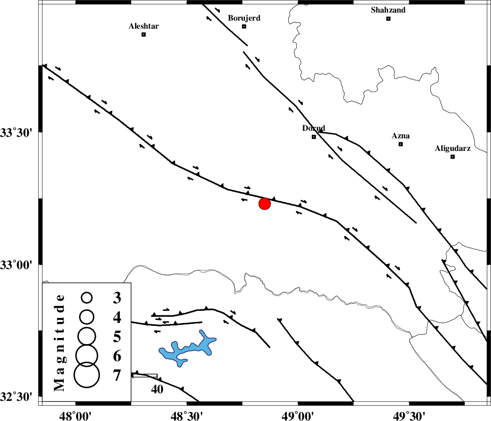
| Location | Lat:33.23 Lon: 48.85 |
| Region | Lorestan Province, 34 km South-West of Dorud |
Nearest Cities |
|
| 6 km North of Chamsangar, Lorestan Province | |
| 11 km West of Sartang barzeh, Lorestan Province | |
| 22 km North of Bargsar, Lorestan Province | |
| 27 km South East of Emanabad, Lorestan Province | |
| 30 km North West of Shulabad, Lorestan Province | |
| Depth | 14 km |
| Agency | |
Faults within 150 km: |
|
| HZF4 (Length: 492 km) , Distance to epicenter: 15 km | |
| DORUD (Length: 100 km) , Distance to epicenter: 37 km | |
| MAIN_ZAGROS_R_F (Length: 1106 km) , Distance to epicenter: 37 km | |
| Number of Phases | 8 |
| RMS | 0.1 |
| Number of Stations | 7 |
| Error in Latitude | >2.2 km |
| Error in Longitude | 4.4 km |
| Error in Depth | 4.9 km |
Download waveform in seisan format
to download seisan software Click here
to access information about IIEES stations Click here
Amplitude | ||||||||
| UID | Agency | Station | Component | Amplitude | Period | Arrival Time | Proccessing Time | Signal Clip |
| 95292 | IIEES | ASAO | N | 356.3 | 0.6 | 2015-03-30 01:05:34 | 2015-03-30 01:51:00 | n |
| 95293 | IIEES | GHVR | N | 182.5 | 0.48 | 2015-03-30 01:05:51 | 2015-03-30 01:51:00 | n |
| 95294 | IIEES | GHVR | E | 226 | 0.56 | 2015-03-30 01:06:04 | 2015-03-30 01:51:00 | n |
Phase | ||||||||||||
| Agency | Station | Component | Phase Type | Phase Quality | First Motion | Observed Arrival Time | Time Residual | Loc. Flag | Input Weight | Distance | Azimuth | |
| IIEES | KHMZ | Z | Pg | E | 2015-03-30 01:04:47 | -0.11 | y | 118 | 61 | |||
| IIEES | KHMZ | Z | Sg | E | 2015-03-30 01:05:02 | 0.01 | y | 118 | 61 | |||
| IIEES | ASAO | Z | Pn | E | 2015-03-30 01:04:58 | -0.09 | y | 182 | 36 | |||
| IIEES | ASAO | N | Sg | E | 2015-03-30 01:05:20 | 0.03 | y | 182 | 36 | |||
| IIEES | CHTH | Z | Pn | E | 2015-03-30 01:05:21 | 0.08 | y | 363 | 35 | |||
| IIEES | NASN | Z | Pn | E | 2015-03-30 01:05:22 | 0.09 | y | 373 | 96 | |||
| IIEES | DAMV | Z | Pn | E | 2015-03-30 01:05:24 | 0.06 | y | 391 | 46 | |||
| IIEES | YZKH | Z | Pn | E | 2015-03-30 01:05:43 | -0.03 | y | 546 | 98 | |||