
Magnitude |
:2.4 |
| Date & Time (UTC) | 2015-03-03 12:41:00.4 |
| Date & Time (Local) | 1393/12/12 16:11:00.4 |
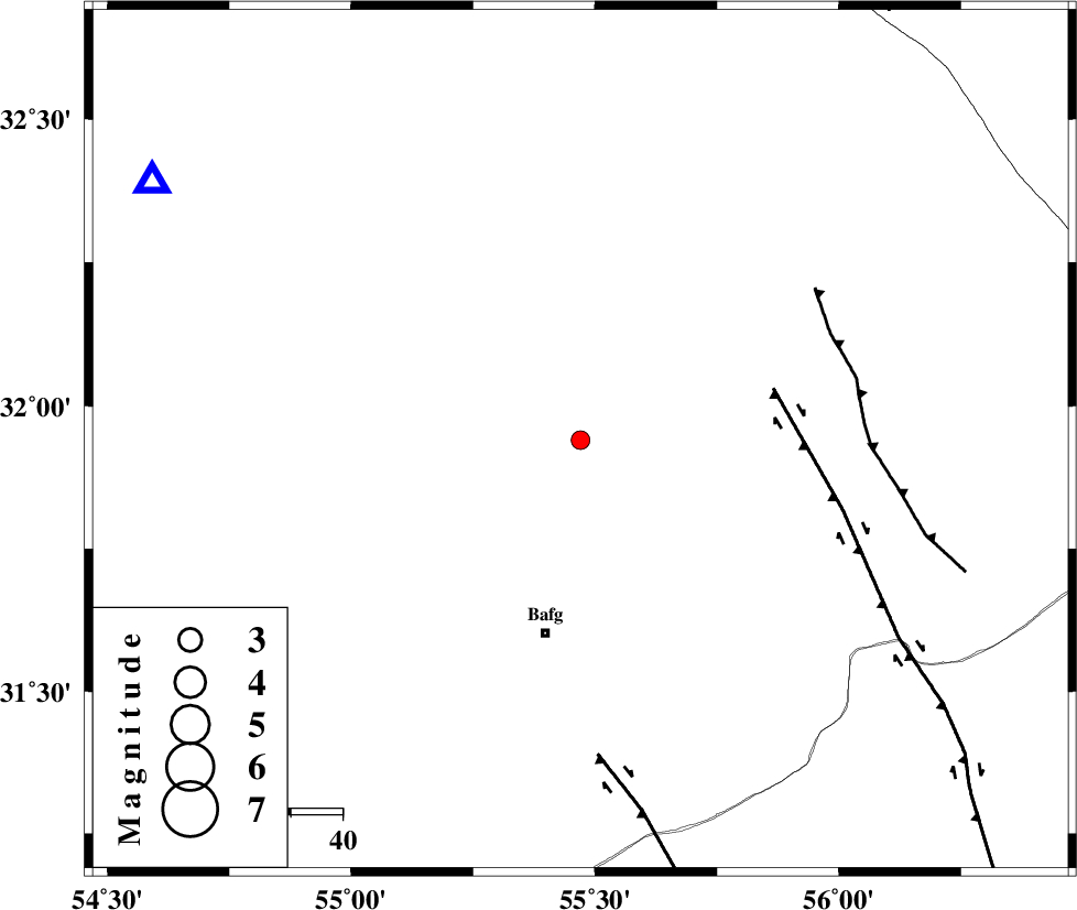
| Location | Lat:31.94 Lon: 55.47 |
| Region | Yazd Province, 38 km North of Bafq |
Nearest Cities |
|
| 35 km North of Mobarake, Yazd Province | |
| 37 km North West of Kushk, Yazd Province | |
| 38 km North of Bafq, Yazd Province | |
| 53 km North West of Behabad, Yazd Province | |
| 62 km North West of Benestan, Yazd Province | |
| Depth | 15 km |
| Agency | |
Faults within 150 km: |
|
| POSHT_E_BADAM_F (Length: 128 km) , Distance to epicenter: 5 km | |
| KUHBANAN_F (Length: 189 km) , Distance to epicenter: 39 km | |
| SARBALA_F (Length: 92 km) , Distance to epicenter: 40 km | |
| Number of Phases | 4 |
| RMS | 0 |
| Number of Stations | 3 |
| Error in Latitude | >1.8 km |
| Error in Longitude | 8.2 km |
| Error in Depth | 0 km |
Download waveform in seisan format
to download seisan software Click here
to access information about IIEES stations Click here
Amplitude | ||||||||
| UID | Agency | Station | Component | Amplitude | Period | Arrival Time | Proccessing Time | Signal Clip |
| 95161 | IIEES | KRBR | N | 21.1 | 0.2 | 2015-03-03 12:42:15 | 2015-03-03 01:41:00 | n |
Phase | ||||||||||||
| Agency | Station | Component | Phase Type | Phase Quality | First Motion | Observed Arrival Time | Time Residual | Loc. Flag | Input Weight | Distance | Azimuth | |
| IIEES | YZKH | Z | Pn | E | 2015-03-03 12:41:24 | y | 97 | 301 | ||||
| IIEES | KRBR | Z | Pg | E | 2015-03-03 12:41:41 | 0 | y | 249 | 150 | |||
| IIEES | KRBR | N | Sg | E | 2015-03-03 12:42:11 | 0 | y | 249 | 150 | |||
| IIEES | BSRN | Z | Pn | E | 2015-03-03 12:41:51 | 0 | y | 345 | 89 | |||