
Magnitude |
:3.1 |
| Date & Time (UTC) | 2015-03-02 04:36:29.3 |
| Date & Time (Local) | 1393/12/11 08:06:29.3 |
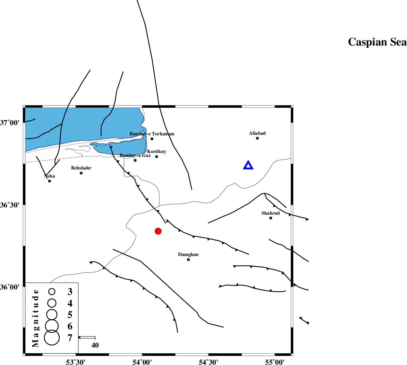
| Location | Lat:36.34 Lon: 54.12 |
| Region | Semnan Province, 28 km North-West of Damghan |
Nearest Cities |
|
| 28 km North West of Damghan, Semnan Province | |
| 32 km North of Seydabad, Semnan Province | |
| 35 km North of Amirabad, Semnan Province | |
| 36 km South East of Sefid chah, Mazandaran Province | |
| 36 km South East of Bishehboneh, Mazandaran Province | |
| Depth | 14 km |
| Agency | |
Faults within 150 km: |
|
| ASTANEH_F (Length: 72 km) , Distance to epicenter: 6 km | |
| DAMGHAN_F (Length: 95 km) , Distance to epicenter: 16 km | |
| N_ALBORZ_F (Length: 360 km) , Distance to epicenter: 18 km | |
| Number of Phases | 7 |
| RMS | 0.2 |
| Number of Stations | 6 |
| Error in Latitude | >6.4 km |
| Error in Longitude | 2.5 km |
| Error in Depth | 5.3 km |
Download waveform in seisan format
to download seisan software Click here
to access information about IIEES stations Click here
Amplitude | ||||||||
| UID | Agency | Station | Component | Amplitude | Period | Arrival Time | Proccessing Time | Signal Clip |
| 95126 | IIEES | THKV | N | 64.1 | 0.43 | 2015-03-02 04:38:08 | 2015-03-02 05:10:00 | n |
| 95127 | IIEES | YZKH | N | 27.9 | 0.9 | 2015-03-02 04:38:44 | 2015-03-02 05:10:00 | n |
Phase | ||||||||||||
| Agency | Station | Component | Phase Type | Phase Quality | First Motion | Observed Arrival Time | Time Residual | Loc. Flag | Input Weight | Distance | Azimuth | |
| IIEES | SHRO | Z | Pg | E | 2015-03-02 04:36:57 | -0.24 | y | 174 | 101 | |||
| IIEES | DAMV | Z | Pn | E | 2015-03-02 04:37:03 | 0.05 | y | 209 | 249 | |||
| IIEES | DAMV | E | Sg | E | 2015-03-02 04:37:28 | -0.27 | y | 209 | 249 | |||
| IIEES | THKV | Z | Pn | E | 2015-03-02 04:37:14 | 0.32 | y | 295 | 262 | |||
| IIEES | GHVR | Z | Pn | E | 2015-03-02 04:37:18 | -0.17 | y | 332 | 233 | |||
| IIEES | NASN | Z | Pn | E | 2015-03-02 04:37:28 | 0.14 | y | 410 | 197 | |||
| IIEES | YZKH | Z | Pn | E | 2015-03-02 04:37:32 | 0.28 | y | 440 | 174 | |||