
Magnitude |
:3.4 |
| Date & Time (UTC) | 2015-02-18 17:55:00.3 |
| Date & Time (Local) | 1393/11/29 21:25:00.3 |
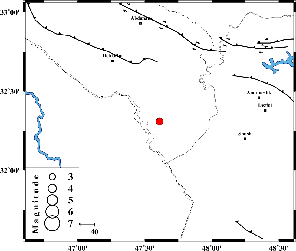
| Location | Lat:32.31 Lon: 47.61 |
| Region | Ilam Province, 54 km South-East of Dehloran |
Nearest Cities |
|
| 35 km South East of Musian, Ilam Province | |
| 54 km South East of Dehloran, Ilam Province | |
| 61 km North West of Shush, Khoozestan Province | |
| 65 km North West of Amaleh teimur, Khoozestan Province | |
| 66 km South of Sarabbagh, Ilam Province | |
| Depth | 18 km |
| Agency | |
Faults within 150 km: |
|
| MFF6 (Length: 144 km) , Distance to epicenter: 42 km | |
| BALARUD_F_Z1 (Length: 87 km) , Distance to epicenter: 59 km | |
| DEZFUL_EMBAYMENT (Length: 228 km) , Distance to epicenter: 61 km | |
| Number of Phases | 6 |
| RMS | 0.1 |
| Number of Stations | 4 |
| Error in Latitude | >2.4 km |
| Error in Longitude | 6.6 km |
| Error in Depth | 6.4 km |
Download waveform in seisan format
to download seisan software Click here
to access information about IIEES stations Click here
Amplitude | ||||||||
| UID | Agency | Station | Component | Amplitude | Period | Arrival Time | Proccessing Time | Signal Clip |
| 95056 | IIEES | SHGR | N | 1003.9 | 0.28 | 2015-02-18 17:55:38 | 2015-02-18 06:26:00 | n |
Phase | ||||||||||||
| Agency | Station | Component | Phase Type | Phase Quality | First Motion | Observed Arrival Time | Time Residual | Loc. Flag | Input Weight | Distance | Azimuth | |
| IIEES | SHGR | Z | Pg | E | 2015-02-18 17:55:19 | 0.2 | y | 115 | 101 | |||
| IIEES | SHGR | E | Sg | E | 2015-02-18 17:55:33 | -0.13 | y | 115 | 101 | |||
| IIEES | KHMZ | Z | Pn | E | 2015-02-18 17:55:41 | -0.05 | y | 272 | 54 | |||
| IIEES | ASAO | Z | Pn | E | 2015-02-18 17:55:49 | -0.19 | y | 335 | 41 | |||
| IIEES | ASAO | N | Sg | E | 2015-02-18 17:56:34 | 0.09 | y | 335 | 41 | |||
| IIEES | NASN | Z | Pn | E | 2015-02-18 17:56:09 | 0.09 | y | 492 | 82 | |||