
Magnitude |
:3.5 |
| Date & Time (UTC) | 2015-02-12 00:33:56.8 |
| Date & Time (Local) | 1393/11/23 04:03:56.8 |
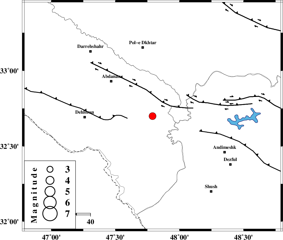
| Location | Lat:32.7 Lon: 47.79 |
| Region | Ilam Province, 51 km South of Pol-e dokhtar |
Nearest Cities |
|
| 30 km South East of Sarabbagh, Ilam Province | |
| 39 km South East of Abdanan, Ilam Province | |
| 42 km West of Bidruyeh, Khoozestan Province | |
| 43 km North West of Hoseinieh, Khoozestan Province | |
| 44 km North East of Musian, Ilam Province | |
| Depth | 14 km |
| Agency | |
Faults within 150 km: |
|
| BALARUD_F_Z1 (Length: 87 km) , Distance to epicenter: 13 km | |
| MFF6 (Length: 144 km) , Distance to epicenter: 18 km | |
| BALARUD_F_Z3 (Length: 53 km) , Distance to epicenter: 29 km | |
| Number of Phases | 7 |
| RMS | 0.2 |
| Number of Stations | 6 |
| Error in Latitude | >5.2 km |
| Error in Longitude | 5.8 km |
| Error in Depth | 4.6 km |
Download waveform in seisan format
to download seisan software Click here
to access information about IIEES stations Click here
Amplitude | ||||||||
| UID | Agency | Station | Component | Amplitude | Period | Arrival Time | Proccessing Time | Signal Clip |
| 95023 | IIEES | GHVR | E | 81.8 | 0.68 | 2015-02-12 00:35:35 | 2015-02-12 01:21:00 | n |
| 95024 | IIEES | GHVR | N | 69.9 | 0.72 | 2015-02-12 00:35:35 | 2015-02-12 01:21:00 | n |
| 95025 | IIEES | AHRM | N | 89.9 | 0.96 | 2015-02-12 00:36:18 | 2015-02-12 01:21:00 | n |
Phase | ||||||||||||
| Agency | Station | Component | Phase Type | Phase Quality | First Motion | Observed Arrival Time | Time Residual | Loc. Flag | Input Weight | Distance | Azimuth | |
| IIEES | KHMZ | Z | Pn | E | 2015-02-12 00:34:33 | 0.16 | y | 233 | 60 | |||
| IIEES | KHMZ | Z | Sg | E | 2015-02-12 00:35:02 | 0.01 | y | 233 | 60 | |||
| IIEES | ASAO | Z | Pn | E | 2015-02-12 00:34:41 | 0.24 | y | 291 | 45 | |||
| IIEES | ASAO | E | Sg | E | 2015-02-12 00:35:18 | -0.07 | y | 291 | 45 | |||
| IIEES | GHVR | E | S | E | 2015-02-12 00:35:31 | 0.06 | y | 376 | 57 | |||
| IIEES | CHTH | Z | P | E | 2015-02-12 00:35:02 | -0.35 | y | 469 | 40 | |||
| IIEES | NASN | Z | Pn | E | 2015-02-12 00:35:02 | -0.19 | y | 470 | 87 | |||