
Magnitude |
:3.7 |
| Date & Time (UTC) | 2015-02-09 16:40:08.0 |
| Date & Time (Local) | 1393/11/20 20:10:08.0 |
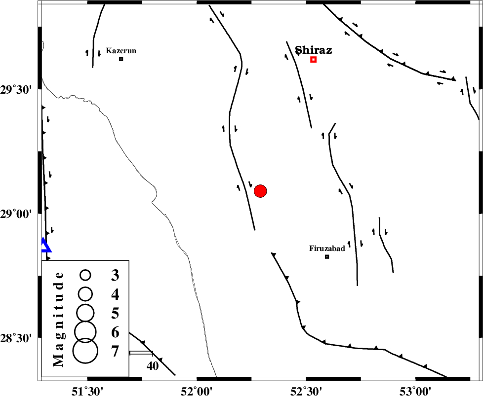
| Location | Lat:29.09 Lon: 52.29 |
| Region | Fars Province, 31 km North-East of Farashband |
Nearest Cities |
|
| 7 km of Dadanjan, Fars Province | |
| 28 km East of Nujin, Fars Province | |
| 30 km North East of Aviz, Fars Province | |
| 30 km North West of Jokan, Fars Province | |
| 31 km North East of Farashband, Fars Province | |
| Depth | 9 km |
| Agency | |
Faults within 150 km: |
|
| KAREBASS_F (Length: 98 km) , Distance to epicenter: 7 km | |
| QIR_F (Length: 130 km) , Distance to epicenter: 28 km | |
| SABZ_PUSHAN_F_Z1 (Length: 69 km) , Distance to epicenter: 34 km | |
| Number of Phases | 7 |
| RMS | 0.1 |
| Number of Stations | 6 |
| Error in Latitude | >3.1 km |
| Error in Longitude | 3.7 km |
| Error in Depth | 9.5 km |
Download waveform in seisan format
to download seisan software Click here
to access information about IIEES stations Click here
Amplitude | ||||||||
| UID | Agency | Station | Component | Amplitude | Period | Arrival Time | Proccessing Time | Signal Clip |
| 95000 | IIEES | AHRM | E | 1889.6 | 0.6 | 2015-02-09 16:40:44 | 2015-02-09 05:09:00 | n |
| 95001 | IIEES | AHRM | N | 2502 | 0.4 | 2015-02-09 16:40:45 | 2015-02-09 05:09:00 | n |
Phase | ||||||||||||
| Agency | Station | Component | Phase Type | Phase Quality | First Motion | Observed Arrival Time | Time Residual | Loc. Flag | Input Weight | Distance | Azimuth | |
| IIEES | AHRM | Z | Pg | E | 2015-02-09 16:40:25 | -0.05 | y | 99.9 | 256 | |||
| IIEES | AHRM | N | Sg | E | 2015-02-09 16:40:38 | 0.05 | y | 99.9 | 256 | |||
| IIEES | NASN | Z | Pn | E | 2015-02-09 16:41:08 | 0.11 | y | 414 | 7 | |||
| IIEES | BNDS | Z | Pn | E | 2015-02-09 16:41:09 | -0.02 | y | 424 | 115 | |||
| IIEES | YZKH | Z | Pn | E | 2015-02-09 16:41:09 | 0.08 | y | 427 | 30 | |||
| IIEES | ASAO | Z | Pn | E | 2015-02-09 16:41:36 | -0.07 | y | 642 | 341 | |||
| IIEES | DAMV | Z | Pn | E | 2015-02-09 16:41:46 | -0.23 | y | 726 | 358 | |||