
Magnitude |
:3.1 |
| Date & Time (UTC) | 2015-02-08 18:01:47.0 |
| Date & Time (Local) | 1393/11/19 21:31:47.0 |
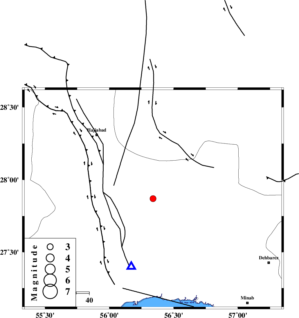
| Location | Lat:27.87 Lon: 56.34 |
| Region | Hormozgan Province, 76 km North of Bandar-e abbas |
Nearest Cities |
|
| 19 km South East of Fareqan, Hormozgan Province | |
| 50 km North East of Fin, Hormozgan Province | |
| 63 km South of Arzuieeh, Kerman Province | |
| 65 km South East of Hajiabad, Hormozgan Province | |
| 65 km South of Shahmaran, Kerman Province | |
| Depth | 14 km |
| Agency | |
Faults within 150 km: |
|
| HZF2 (Length: 437 km) , Distance to epicenter: 7 km | |
| MAIN_ZAGROS_R_F (Length: 1106 km) , Distance to epicenter: 34 km | |
| ZENDAN_MINAB_F_Z1 (Length: 183 km) , Distance to epicenter: 66 km | |
| Number of Phases | 5 |
| RMS | 0 |
| Number of Stations | 4 |
| Error in Latitude | >1.4 km |
| Error in Longitude | 5.4 km |
| Error in Depth | 4.1 km |
Download waveform in seisan format
to download seisan software Click here
to access information about IIEES stations Click here
Amplitude | ||||||||
| UID | Agency | Station | Component | Amplitude | Period | Arrival Time | Proccessing Time | Signal Clip |
| 94989 | IIEES | KRBR | N | 117.7 | 0.28 | 2015-02-08 18:02:57 | 2015-02-08 07:33:00 | n |
| 94990 | IIEES | KRBR | E | 119.4 | 0.52 | 2015-02-08 18:02:58 | 2015-02-08 07:33:00 | n |
Phase | ||||||||||||
| Agency | Station | Component | Phase Type | Phase Quality | First Motion | Observed Arrival Time | Time Residual | Loc. Flag | Input Weight | Distance | Azimuth | |
| IIEES | BNDS | Z | Pg | E | 2015-02-08 18:01:56 | -0.01 | y | 54.4 | 198 | |||
| IIEES | KRBR | Z | Pn | E | 2015-02-08 18:02:24 | 0.06 | y | 238 | 10 | |||
| IIEES | KRBR | N | Sg | E | 2015-02-08 18:02:54 | -0.01 | y | 238 | 10 | |||
| IIEES | ZHSF | Z | Pn | E | 2015-02-08 18:02:53 | 0 | y | 474 | 65 | |||
| IIEES | BSRN | Z | Pn | E | 2015-02-08 18:03:00 | -0.07 | y | 528 | 30 | |||