
Magnitude |
:1.8 |
| Date & Time (UTC) | 2015-02-05 22:12:14.3 |
| Date & Time (Local) | 1393/11/17 01:42:14.3 |
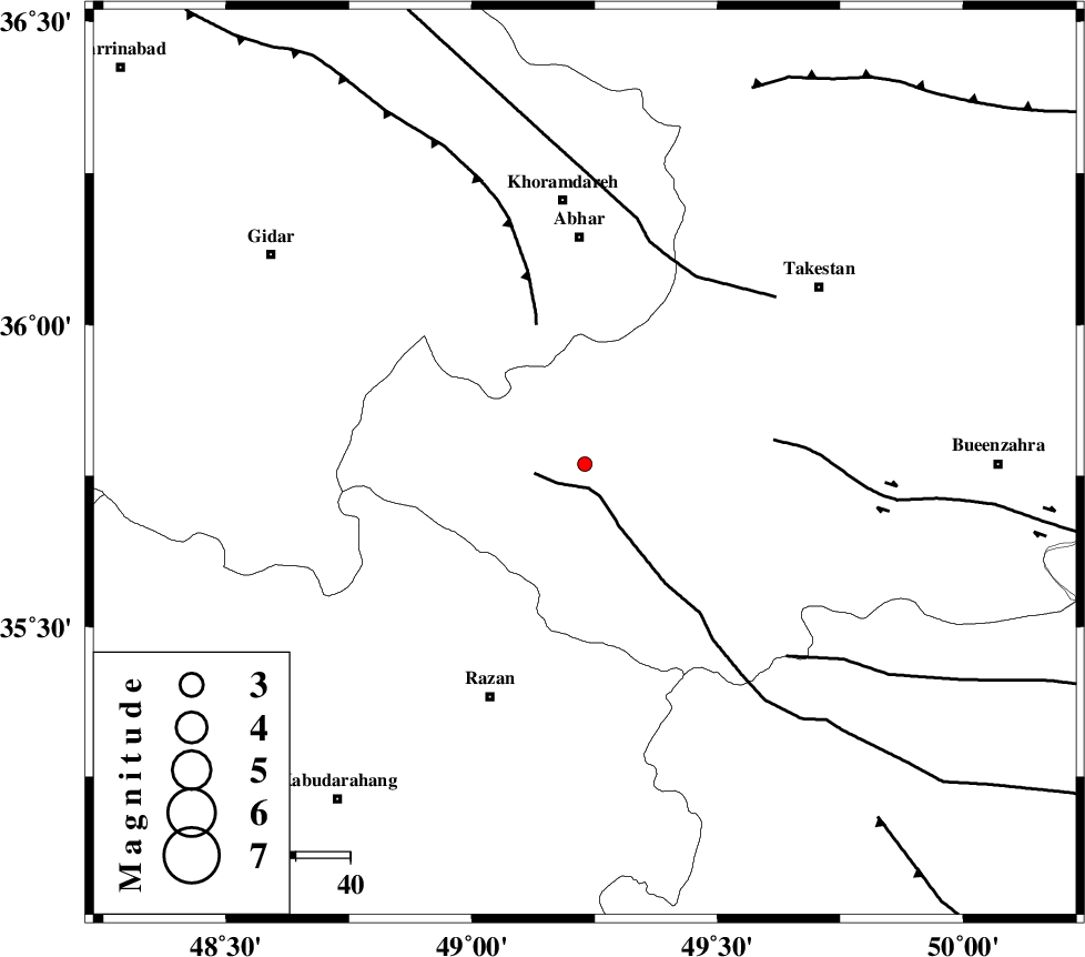
| Location | Lat:35.77 Lon: 49.23 |
| Region | Ghazvin Province, 42 km South of Abhar |
Nearest Cities |
|
| 5 km North of Ab-e garm, Ghazvin Province | |
| 17 km West of Hoseynabad, Ghazvin Province | |
| 20 km North of Avaj, Ghazvin Province | |
| 27 km North West of Kolanjin, Ghazvin Province | |
| 28 km South of Darsajin, Zanjan Province | |
| Depth | 14 km |
| Agency | |
Faults within 150 km: |
|
| KUSHK_E_NOSRAT_F (Length: 230 km) , Distance to epicenter: 5 km | |
| SOLTANIYEH_F (Length: 119 km) , Distance to epicenter: 27 km | |
| IPAK_F (Length: 80 km) , Distance to epicenter: 35 km | |
| Number of Phases | 5 |
| RMS | 0.1 |
| Number of Stations | 4 |
| Error in Latitude | >1.9 km |
| Error in Longitude | 4.4 km |
| Error in Depth | 3.8 km |
Download waveform in seisan format
to download seisan software Click here
to access information about IIEES stations Click here
Amplitude | ||||||||
| UID | Agency | Station | Component | Amplitude | Period | Arrival Time | Proccessing Time | Signal Clip |
| 94973 | IIEES | CHTH | N | 15.3 | 0.36 | 2015-02-05 22:13:10 | 2015-02-06 02:03:00 | n |
| 94974 | IIEES | CHTH | E | 11 | 0.48 | 2015-02-05 22:13:10 | 2015-02-06 02:03:00 | n |
Phase | ||||||||||||
| Agency | Station | Component | Phase Type | Phase Quality | First Motion | Observed Arrival Time | Time Residual | Loc. Flag | Input Weight | Distance | Azimuth | |
| IIEES | ZNJK | Z | Pg | E | 2015-02-05 22:12:33 | -0.02 | y | 111 | 334 | |||
| IIEES | ASAO | Z | Pg | E | 2015-02-05 22:12:39 | -0.15 | y | 154 | 152 | |||
| IIEES | ASAO | E | Sg | E | 2015-02-05 22:12:58 | 0.02 | y | 154 | 152 | |||
| IIEES | CHTH | Z | Pn | E | 2015-02-05 22:12:43 | 0.03 | y | 172 | 84 | |||
| IIEES | KHMZ | Z | Pn | E | 2015-02-05 22:12:51 | 0.12 | y | 235 | 163 | |||