
Magnitude |
:2.4 |
| Date & Time (UTC) | 2015-02-01 16:46:52.1 |
| Date & Time (Local) | 1393/11/12 20:16:52.1 |
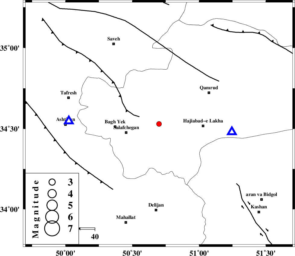
| Location | Lat:34.53 Lon: 50.7 |
| Region | Qom Province, 20 km South-West of Qom |
Nearest Cities |
|
| 20 km South West of Qom, Qom Province | |
| 23 km North West of Kahak, Qom Province | |
| 23 km North East of Salafchegan, Qom Province | |
| 30 km North East of Bagh yek, Qom Province | |
| 30 km North West of Hajiabad-e lakha, Qom Province | |
| Depth | 16 km |
| Agency | |
Faults within 150 km: |
|
| INDES_F (Length: 98 km) , Distance to epicenter: 14 km | |
| KUSHK_E_NOSRAT_F (Length: 230 km) , Distance to epicenter: 46 km | |
| TAFRESH_F (Length: 117 km) , Distance to epicenter: 55 km | |
| Number of Phases | 7 |
| RMS | 0.1 |
| Number of Stations | 6 |
| Error in Latitude | >1.5 km |
| Error in Longitude | 1.7 km |
| Error in Depth | 4.2 km |
Download waveform in seisan format
to download seisan software Click here
to access information about IIEES stations Click here
Amplitude | ||||||||
| UID | Agency | Station | Component | Amplitude | Period | Arrival Time | Proccessing Time | Signal Clip |
| 94920 | IIEES | DAMV | E | 50.4 | 0.16 | 2015-02-01 16:47:44 | 2015-02-01 05:10:00 | n |
Phase | ||||||||||||
| Agency | Station | Component | Phase Type | Phase Quality | First Motion | Observed Arrival Time | Time Residual | Loc. Flag | Input Weight | Distance | Azimuth | |
| IIEES | GHVR | Z | Pg | E | 2015-02-01 16:47:01 | -0.11 | y | 50.2 | 96 | |||
| IIEES | ASAO | Z | Pg | E | 2015-02-01 16:47:03 | -0.05 | y | 62.2 | 272 | |||
| IIEES | KHMZ | Z | Pg | E | 2015-02-01 16:47:11 | 0.12 | y | 111 | 218 | |||
| IIEES | CHTH | Z | Pg | E | 2015-02-01 16:47:18 | -0.11 | y | 158 | 14 | |||
| IIEES | DAMV | Z | Pg | E | 2015-02-01 16:47:20 | 0.05 | y | 168 | 43 | |||
| IIEES | DAMV | E | Sg | E | 2015-02-01 16:47:40 | 0.11 | y | 168 | 43 | |||
| IIEES | NASN | Z | Pn | E | 2015-02-01 16:47:33 | -0.02 | y | 274 | 134 | |||