
Magnitude |
:2.5 |
| Date & Time (UTC) | 2015-01-19 04:11:50.0 |
| Date & Time (Local) | 1393/10/29 07:41:50.0 |
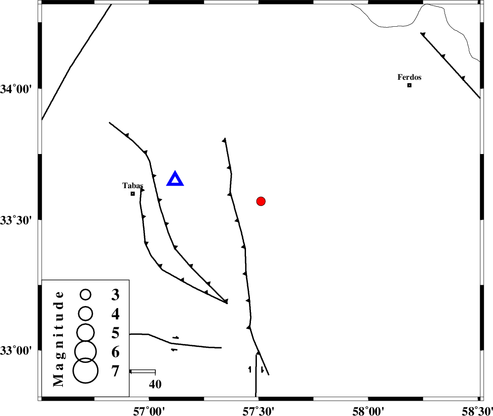
| Location | Lat:33.57 Lon: 57.51 |
| Region | Khorasan(center) Province, 54 km East of Tabas |
Nearest Cities |
|
| 18 km South East of Arsak, Khorasan(center) Province | |
| 31 km North of Dihuk, Yazd Province | |
| 34 km South of Boshravieh, Khorasan(center) Province | |
| 36 km South East of Reqqeh, Khorasan(center) Province | |
| 54 km East of Tabas, Yazd Province | |
| Depth | 14 km |
| Agency | |
Faults within 150 km: |
|
| ESFARDIAR_F (Length: 94 km) , Distance to epicenter: 14 km | |
| TABAS_F1 (Length: 91 km) , Distance to epicenter: 41 km | |
| TABAS_F2 (Length: 67 km) , Distance to epicenter: 46 km | |
| Number of Phases | 5 |
| RMS | 0.1 |
| Number of Stations | 3 |
| Error in Latitude | >2.7 km |
| Error in Longitude | 2.7 km |
| Error in Depth | 5.9 km |
Download waveform in seisan format
to download seisan software Click here
to access information about IIEES stations Click here
Amplitude | ||||||||
| UID | Agency | Station | Component | Amplitude | Period | Arrival Time | Proccessing Time | Signal Clip |
| 94815 | IIEES | TABS | N | 907.6 | 0.2 | 2015-01-19 04:12:02 | 2015-01-19 04:38:00 | n |
| 94816 | IIEES | TABS | E | 585.9 | 0.2 | 2015-01-19 04:12:02 | 2015-01-19 04:38:00 | n |
| 94817 | IIEES | YZKH | E | 13.7 | 0.44 | 2015-01-19 04:13:18 | 2015-01-19 04:38:00 | n |
Phase | ||||||||||||
| Agency | Station | Component | Phase Type | Phase Quality | First Motion | Observed Arrival Time | Time Residual | Loc. Flag | Input Weight | Distance | Azimuth | |
| IIEES | TABS | Z | Pg | E | 2015-01-19 04:11:56 | -0.02 | y | 37.2 | 284 | |||
| IIEES | TABS | N | Sg | E | 2015-01-19 04:12:02 | -0.02 | y | 37.2 | 284 | |||
| IIEES | BSRN | Z | Pn | E | 2015-01-19 04:12:26 | -0.05 | y | 234 | 139 | |||
| IIEES | YZKH | Z | Pn | E | D | 2015-01-19 04:12:35 | 0.15 | y | 302 | 245 | ||
| IIEES | YZKH | E | Sg | E | 2015-01-19 04:13:15 | -0.04 | y | 302 | 245 | |||