
Magnitude |
:2 |
| Date & Time (UTC) | 2015-01-08 23:13:01.4 |
| Date & Time (Local) | 1393/10/19 02:43:01.4 |
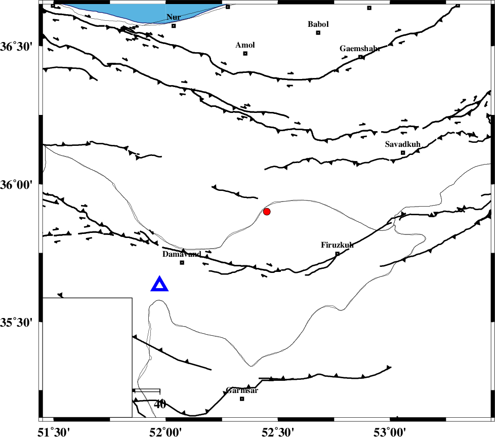
| Location | Lat:35.9 Lon: 52.45 |
| Region | Tehran Province, 33 km North-West of Firuzkuh |
Nearest Cities |
|
| 13 km North of Arjomand, Tehran Province | |
| 17 km East of Baijan, Mazandaran Province | |
| 23 km East of Gaznak, Mazandaran Province | |
| 24 km North West of Shahrabad, Tehran Province | |
| 26 km North East of Rineh, Mazandaran Province | |
| Depth | 22 km |
| Agency | |
Faults within 150 km: |
|
| MOSHA_F (Length: 234 km) , Distance to epicenter: 23 km | |
| N_ALBORZ_F (Length: 360 km) , Distance to epicenter: 34 km | |
| ATARI_F (Length: 185 km) , Distance to epicenter: 51 km | |
| Number of Phases | 5 |
| RMS | 0.1 |
| Number of Stations | 4 |
| Error in Latitude | >3.1 km |
| Error in Longitude | 5.6 km |
| Error in Depth | 4.6 km |
Download waveform in seisan format
to download seisan software Click here
to access information about IIEES stations Click here
Amplitude | ||||||||
| UID | Agency | Station | Component | Amplitude | Period | Arrival Time | Proccessing Time | Signal Clip |
| 94738 | IIEES | GHVR | E | 14.1 | 0.4 | 2015-01-08 23:14:03 | 2015-01-08 11:51:00 | n |
| 94739 | IIEES | ASAO | N | 7.5 | 0.44 | 2015-01-08 23:14:17 | 2015-01-08 11:51:00 | n |
| 94740 | IIEES | ASAO | E | 7.2 | 0.4 | 2015-01-08 23:14:17 | 2015-01-08 11:51:00 | n |
Phase | ||||||||||||
| Agency | Station | Component | Phase Type | Phase Quality | First Motion | Observed Arrival Time | Time Residual | Loc. Flag | Input Weight | Distance | Azimuth | |
| IIEES | DAMV | Z | Pg | E | 2015-01-08 23:13:11 | 0.02 | y | 52.4 | 235 | |||
| IIEES | CHTH | Z | Pn | E | 2015-01-08 23:13:23 | -0.11 | y | 119 | 271 | |||
| IIEES | GHVR | Z | Pn | E | 2015-01-08 23:13:32 | 0.13 | y | 192 | 215 | |||
| IIEES | GHVR | E | Sg | E | 2015-01-08 23:13:54 | -0.14 | y | 192 | 215 | |||
| IIEES | ASAO | N | Sg | E | 2015-01-08 23:14:15 | 0.11 | y | 267 | 236 | |||