
Magnitude |
:3.4 |
| Date & Time (UTC) | 2015-01-07 00:32:07.7 |
| Date & Time (Local) | 1393/10/17 04:02:07.7 |
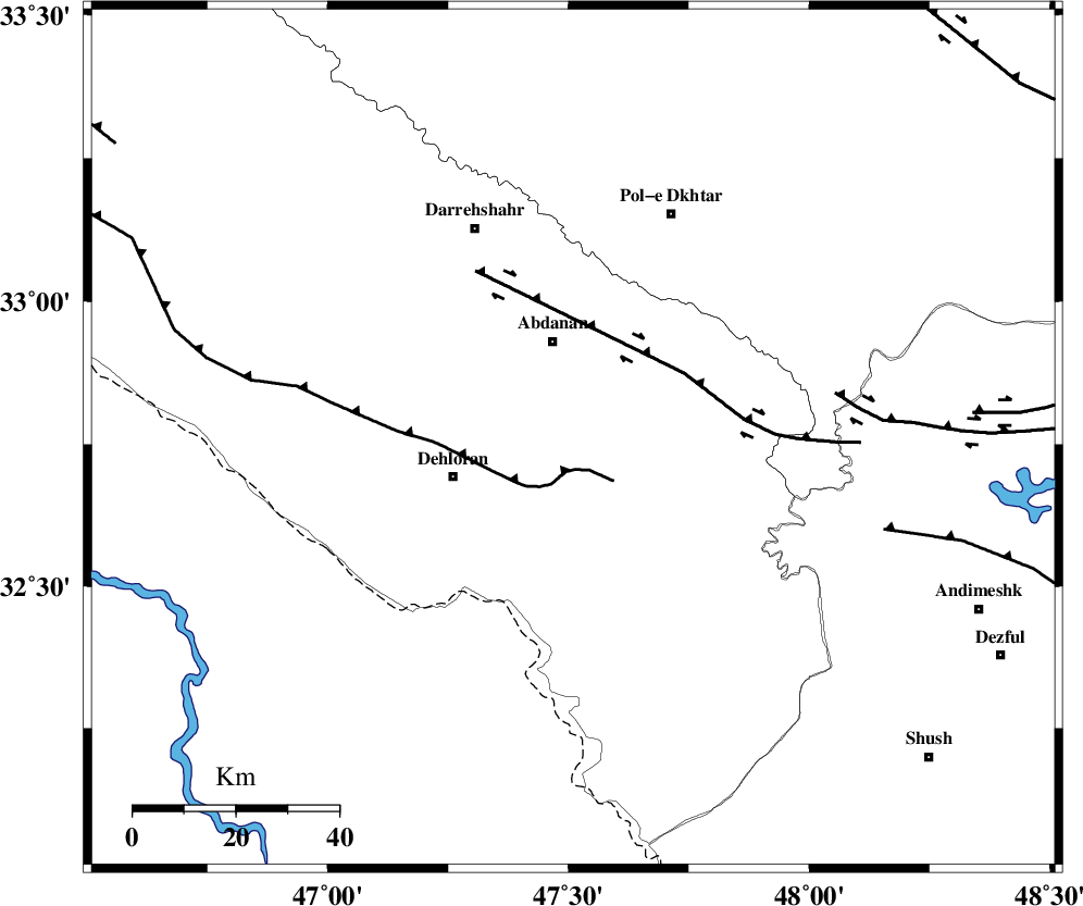
| Location | Lat:32.76 Lon: 47.51 |
| Region | Ilam Province, 20 km South of Abdanan |
Nearest Cities |
|
| 16 km South of Sarabbagh, Ilam Province | |
| 19 km South of Abdanan, Ilam Province | |
| 25 km North East of Dehloran, Ilam Province | |
| 28 km North East of Musian, Ilam Province | |
| 41 km South West of Sarab hammam, Lorestan Province | |
| Depth | 18 km |
| Agency | |
Faults within 150 km: |
|
| MFF6 (Length: 144 km) , Distance to epicenter: 6 km | |
| BALARUD_F_Z1 (Length: 87 km) , Distance to epicenter: 25 km | |
| BALARUD_F_Z3 (Length: 53 km) , Distance to epicenter: 52 km | |
| Number of Phases | 6 |
| RMS | 0.1 |
| Number of Stations | 5 |
| Error in Latitude | >1.7 km |
| Error in Longitude | 3.6 km |
| Error in Depth | 4.1 km |
Download waveform in seisan format
to download seisan software Click here
to access information about IIEES stations Click here
Amplitude | ||||||||
| UID | Agency | Station | Component | Amplitude | Period | Arrival Time | Proccessing Time | Signal Clip |
| 94723 | IIEES | SHGR | N | 595.7 | 0.4 | 2015-01-07 00:32:52 | 2015-01-07 01:08:00 | n |
| 94724 | IIEES | SHGR | E | 827 | 0.48 | 2015-01-07 00:32:52 | 2015-01-07 01:08:00 | n |
Phase | ||||||||||||
| Agency | Station | Component | Phase Type | Phase Quality | First Motion | Observed Arrival Time | Time Residual | Loc. Flag | Input Weight | Distance | Azimuth | |
| IIEES | SHGR | Z | Pg | E | 2015-01-07 00:32:31 | 0.01 | y | 141 | 120 | |||
| IIEES | KHMZ | Z | Pn | E | 2015-01-07 00:32:46 | -0.06 | y | 253 | 64 | |||
| IIEES | SNGE | Z | Pn | E | 2015-01-07 00:32:47 | -0.01 | y | 260 | 357 | |||
| IIEES | ASAO | Z | Pn | E | 2015-01-07 00:32:53 | 0.12 | y | 306 | 49 | |||
| IIEES | ASAO | N | Sg | E | 2015-01-07 00:33:33 | 0 | y | 306 | 49 | |||
| IIEES | GHVR | Z | Pn | E | 2015-01-07 00:33:04 | -0.05 | y | 396 | 60 | |||