
Magnitude |
:3.5 |
| Date & Time (UTC) | 2015-01-06 21:20:44.9 |
| Date & Time (Local) | 1393/10/17 00:50:44.9 |
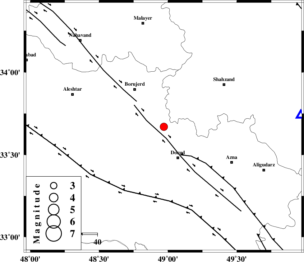
| Location | Lat:33.67 Lon: 48.97 |
| Region | Lorestan Province, 23 km North-West of Dorud |
Nearest Cities |
|
| 7 km North of Kagheh, Lorestan Province | |
| 8 km North of Chalanchulan, Lorestan Province | |
| 15 km North of Razan, Lorestan Province | |
| 16 km South of Hashian, Markazi Province | |
| 16 km North of Void, Lorestan Province | |
| Depth | 16 km |
| Agency | |
Faults within 150 km: |
|
| DORUD (Length: 100 km) , Distance to epicenter: 5 km | |
| MAIN_ZAGROS_R_F (Length: 1106 km) , Distance to epicenter: 22 km | |
| NAHAVAND_F (Length: 102 km) , Distance to epicenter: 25 km | |
| Number of Phases | 7 |
| RMS | 0.2 |
| Number of Stations | 5 |
| Error in Latitude | >2.5 km |
| Error in Longitude | 2 km |
| Error in Depth | 5.3 km |
Download waveform in seisan format
to download seisan software Click here
to access information about IIEES stations Click here
Amplitude | ||||||||
| UID | Agency | Station | Component | Amplitude | Period | Arrival Time | Proccessing Time | Signal Clip |
| 94721 | IIEES | SHGR | N | 663.9 | 0.72 | 2015-01-06 21:21:42 | 2015-01-06 09:41:00 | n |
| 94722 | IIEES | SNGE | N | 347.8 | 0.56 | 2015-01-06 21:21:53 | 2015-01-06 09:41:00 | n |
Phase | ||||||||||||
| Agency | Station | Component | Phase Type | Phase Quality | First Motion | Observed Arrival Time | Time Residual | Loc. Flag | Input Weight | Distance | Azimuth | |
| IIEES | KHMZ | Z | Pg | E | 2015-01-06 21:21:00 | -0.29 | y | 92.7 | 85 | |||
| IIEES | ASAO | Z | Pg | E | 2015-01-06 21:21:08 | 0.22 | y | 138 | 45 | |||
| IIEES | ASAO | N | Sg | E | 2015-01-06 21:21:25 | 0.02 | y | 138 | 45 | |||
| IIEES | SHGR | Z | Pn | E | 2015-01-06 21:21:14 | 0.15 | y | 174 | 185 | |||
| IIEES | SNGE | Z | Pn | E | 2015-01-06 21:21:19 | -0.25 | y | 217 | 317 | |||
| IIEES | SNGE | N | Sg | E | 2015-01-06 21:21:46 | 0.06 | y | 217 | 317 | |||
| IIEES | GHVR | Z | Pn | E | 2015-01-06 21:21:21 | 0.09 | y | 229 | 66 | |||