
Magnitude |
:4.1 |
| Date & Time (UTC) | 2015-01-06 16:34:44.4 |
| Date & Time (Local) | 1393/10/16 20:04:44.4 |
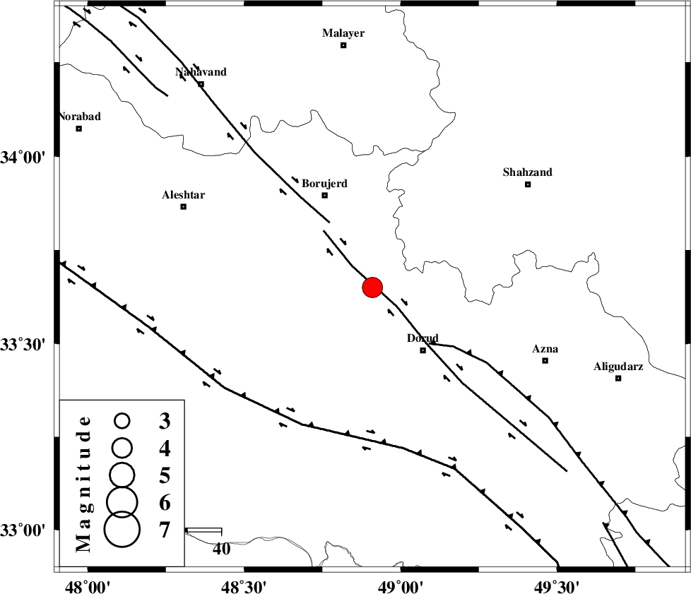
| Location | Lat:33.65 Lon: 48.91 |
| Region | Lorestan Province, 24 km North-West of Dorud |
Nearest Cities |
|
| 3 km of Chalanchulan, Lorestan Province | |
| 6 km North of Kagheh, Lorestan Province | |
| 10 km North of Razan, Lorestan Province | |
| 15 km North of Void, Lorestan Province | |
| 21 km South West of Hashian, Markazi Province | |
| Depth | 15 km |
| Agency | |
Faults within 150 km: |
|
| DORUD (Length: 100 km) , Distance to epicenter: 1 km | |
| NAHAVAND_F (Length: 102 km) , Distance to epicenter: 23 km | |
| MAIN_ZAGROS_R_F (Length: 1106 km) , Distance to epicenter: 24 km | |
| Number of Phases | 5 |
| RMS | 0.4 |
| Number of Stations | 5 |
| Error in Latitude | >3.9 km |
| Error in Longitude | 5.1 km |
| Error in Depth | 8.4 km |
Download waveform in seisan format
to download seisan software Click here
to access information about IIEES stations Click here
Amplitude | ||||||||
| UID | Agency | Station | Component | Amplitude | Period | Arrival Time | Proccessing Time | Signal Clip |
| 94711 | IIEES | ASAO | E | 2905.6 | 0.4 | 2015-01-06 16:35:28 | 2015-01-06 04:57:00 | n |
| 94712 | IIEES | ASAO | N | 3766.9 | 0.52 | 2015-01-06 16:35:31 | 2015-01-06 04:57:00 | n |
| 94713 | IIEES | SHGR | N | 3948.6 | 0.36 | 2015-01-06 16:35:42 | 2015-01-06 04:57:00 | n |
| 94714 | IIEES | SHGR | E | 2669.6 | 0.44 | 2015-01-06 16:35:42 | 2015-01-06 04:57:00 | n |
| 94715 | IIEES | GHVR | N | 1233.4 | 0.48 | 2015-01-06 16:36:03 | 2015-01-06 04:57:00 | n |
Phase | ||||||||||||
| Agency | Station | Component | Phase Type | Phase Quality | First Motion | Observed Arrival Time | Time Residual | Loc. Flag | Input Weight | Distance | Azimuth | |
| IIEES | KHMZ | Z | Pg | E | 2015-01-06 16:35:00 | -0.66 | y | 98 | 84 | |||
| IIEES | ASAO | Z | Pg | E | 2015-01-06 16:35:08 | 0.29 | y | 143 | 46 | |||
| IIEES | SHGR | Z | Pg | E | 2015-01-06 16:35:12 | 0.13 | y | 172 | 183 | |||
| IIEES | SNGE | Z | Pg | E | 2015-01-06 16:35:19 | -0.2 | y | 215 | 318 | |||
| IIEES | GHVR | Z | Pn | E | 2015-01-06 16:35:21 | 0.45 | y | 234 | 66 | |||