
Magnitude |
:3.1 |
| Date & Time (UTC) | 2015-01-04 17:01:19.8 |
| Date & Time (Local) | 1393/10/14 20:31:19.8 |
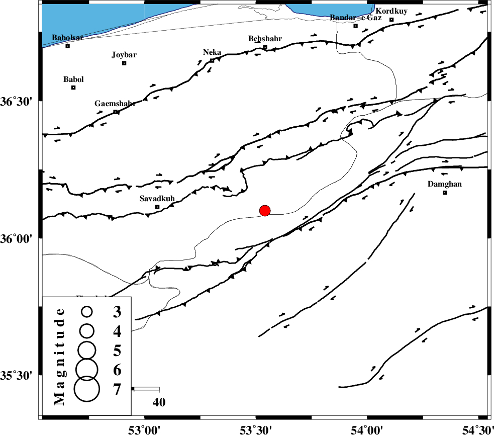
| Location | Lat:36.1 Lon: 53.54 |
| Region | Mazandaran Province, 43 km East of Pol-E-Sefid |
Nearest Cities |
|
| 15 km South of Kiasar, Mazandaran Province | |
| 19 km South West of Talma darreh, Mazandaran Province | |
| 28 km North East of Sangdeh, Mazandaran Province | |
| 31 km South East of Khalkhil, Mazandaran Province | |
| 34 km North East of Chashem, Semnan Province | |
| Depth | 14 km |
| Agency | |
Faults within 150 km: |
|
| N_ALBORZ_F (Length: 360 km) , Distance to epicenter: 26 km | |
| DAMGHAN_F (Length: 95 km) , Distance to epicenter: 27 km | |
| ATARI_F (Length: 185 km) , Distance to epicenter: 36 km | |
| Number of Phases | 8 |
| RMS | 0.1 |
| Number of Stations | 5 |
| Error in Latitude | >2.6 km |
| Error in Longitude | 4.6 km |
| Error in Depth | 6.2 km |
Download waveform in seisan format
to download seisan software Click here
to access information about IIEES stations Click here
Amplitude | ||||||||
| UID | Agency | Station | Component | Amplitude | Period | Arrival Time | Proccessing Time | Signal Clip |
| 94691 | IIEES | THKV | N | 111.6 | 0.52 | 2015-01-04 17:02:37 | 2015-01-04 05:24:00 | n |
| 94692 | IIEES | GHVR | N | 95.5 | 0.52 | 2015-01-04 17:02:43 | 2015-01-04 05:24:00 | n |
| 94693 | IIEES | GHVR | E | 89.6 | 0.36 | 2015-01-04 17:02:43 | 2015-01-04 05:24:00 | n |
Phase | ||||||||||||
| Agency | Station | Component | Phase Type | Phase Quality | First Motion | Observed Arrival Time | Time Residual | Loc. Flag | Input Weight | Distance | Azimuth | |
| IIEES | CHTH | Z | Pn | E | 2015-01-04 17:01:54 | -0.01 | y | 218 | 265 | |||
| IIEES | CHTH | E | Sg | E | 2015-01-04 17:02:21 | 0.04 | y | 218 | 265 | |||
| IIEES | THKV | Z | Pn | E | 2015-01-04 17:01:57 | 0.15 | y | 240 | 266 | |||
| IIEES | THKV | N | Sg | E | 2015-01-04 17:02:27 | -0.03 | y | 240 | 266 | |||
| IIEES | GHVR | Z | Pn | E | 2015-01-04 17:02:01 | -0.14 | y | 275 | 230 | |||
| IIEES | ASAO | Z | Pn | E | 2015-01-04 17:02:12 | -0.11 | y | 362 | 243 | |||
| IIEES | NASN | Z | Pn | E | 2015-01-04 17:02:14 | 0.01 | y | 372 | 191 | |||
| IIEES | NASN | E | S | E | 2015-01-04 17:02:53 | 0.08 | y | 372 | 191 | |||