
Magnitude |
:2.8 |
| Date & Time (UTC) | 2015-01-04 12:51:07.1 |
| Date & Time (Local) | 1393/10/14 16:21:07.1 |
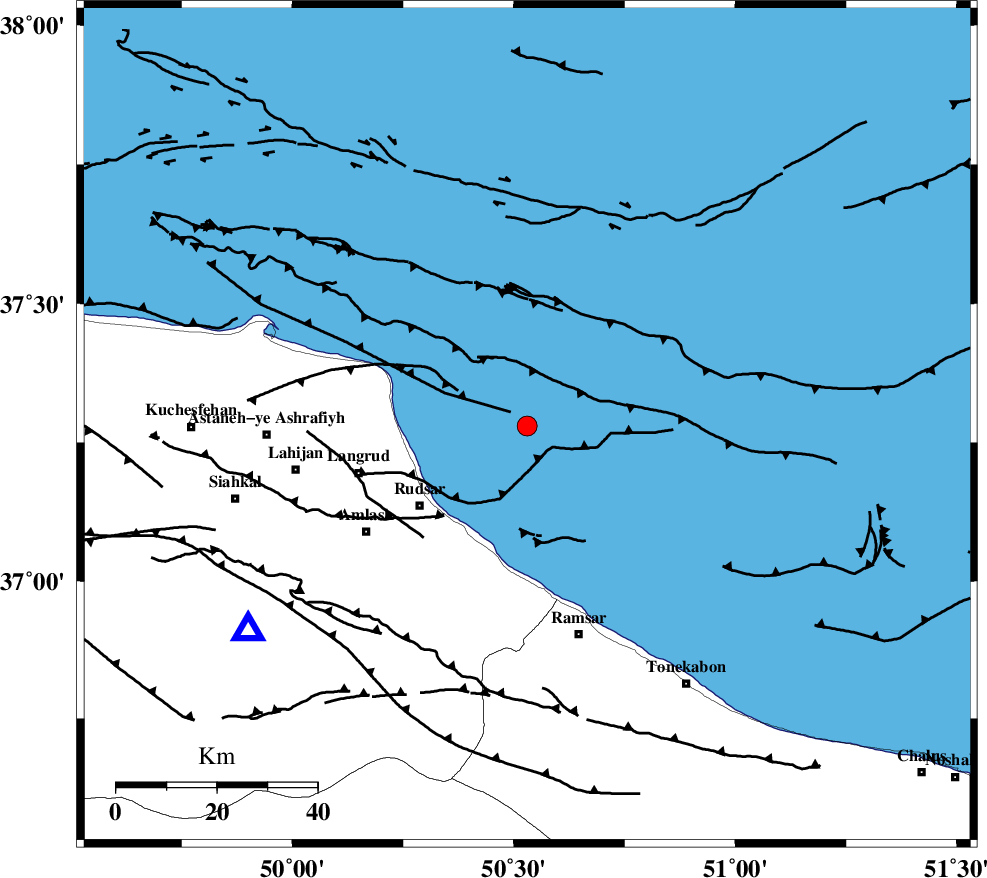
| Location | Lat:37.28 Lon: 50.53 |
| Region | Caspian Sea, 27 km North-East of Rudsar |
Nearest Cities |
|
| 25 km North East of Rezamahalleh, Gilan Province | |
| 26 km North East of Kohnehgorab, Gilan Province | |
| 27 km North East of Rudsar, Gilan Province | |
| 27 km North East of Chali-ye paeen, Gilan Province | |
| 29 km North East of Vajargah, Gilan Province | |
| Depth | 27 km |
| Agency | |
Faults within 150 km: |
|
| LAHIJAN_F (Length: 92 km) , Distance to epicenter: 32 km | |
| KHAZAR_F (Length: 523 km) , Distance to epicenter: 34 km | |
| BONAN_F (Length: 74 km) , Distance to epicenter: 64 km | |
| Number of Phases | 7 |
| RMS | 0.1 |
| Number of Stations | 6 |
| Error in Latitude | >2.8 km |
| Error in Longitude | 2.2 km |
| Error in Depth | 4.8 km |
Download waveform in seisan format
to download seisan software Click here
to access information about IIEES stations Click here
Amplitude | ||||||||
| UID | Agency | Station | Component | Amplitude | Period | Arrival Time | Proccessing Time | Signal Clip |
| 94683 | IIEES | THKV | N | 306.2 | 0.32 | 2015-01-04 12:51:53 | 2015-01-04 03:12:00 | n |
| 94684 | IIEES | SNGE | N | 9.3 | 0.44 | 2015-01-04 12:52:41 | 2015-01-04 03:12:00 | n |
Phase | ||||||||||||
| Agency | Station | Component | Phase Type | Phase Quality | First Motion | Observed Arrival Time | Time Residual | Loc. Flag | Input Weight | Distance | Azimuth | |
| IIEES | THKV | Z | Pg | E | 2015-01-04 12:51:32 | 0.02 | y | 155 | 168 | |||
| IIEES | THKV | N | Sg | E | 2015-01-04 12:51:51 | 0.1 | y | 155 | 168 | |||
| IIEES | CHTH | Z | Pg | E | 2015-01-04 12:51:33 | -0.11 | y | 161 | 160 | |||
| IIEES | ZNJK | Z | Pg | E | 2015-01-04 12:51:36 | 0.04 | y | 178 | 248 | |||
| IIEES | ZNJK | E | Sg | E | 2015-01-04 12:51:57 | -0.06 | y | 178 | 248 | |||
| IIEES | DAMV | Z | Pn | E | 2015-01-04 12:51:41 | -0.05 | y | 224 | 144 | |||
| IIEES | GRMI | Z | Pn | E | 2015-01-04 12:51:49 | 0.06 | y | 287 | 307 | |||