
Magnitude |
:3.5 |
| Date & Time (UTC) | 2014-12-22 23:21:04.6 |
| Date & Time (Local) | 1393/10/2 02:51:04.6 |
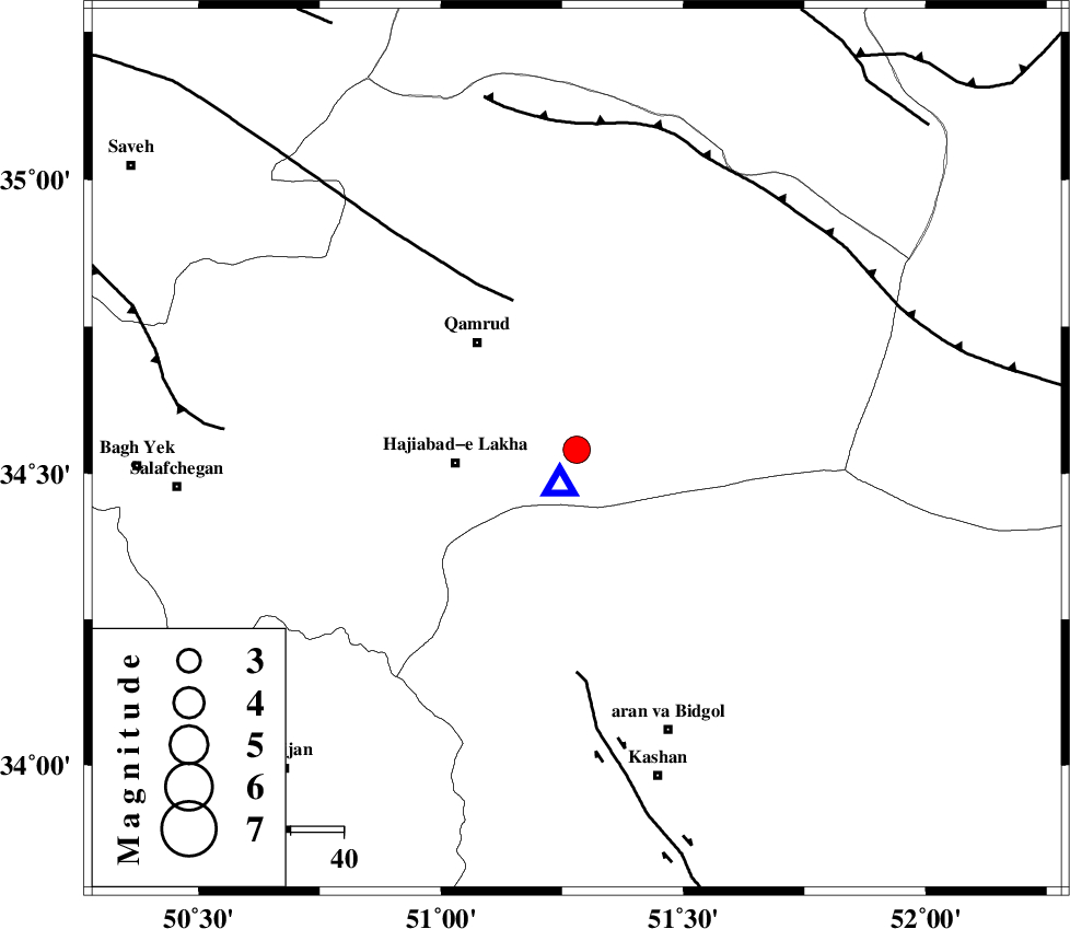
| Location | Lat:34.54 Lon: 51.28 |
| Region | Qom Province, 40 km South-East of Qom |
Nearest Cities |
|
| 23 km North East of Hajiabad-e lakha, Qom Province | |
| 28 km South East of Qamrud, Qom Province | |
| 40 km South East of Qom, Qom Province | |
| 41 km North of Mashgan, Esfahan Province | |
| 41 km North East of Kahak, Qom Province | |
| Depth | 7 km |
| Agency | |
Faults within 150 km: |
|
| KUSHK_E_NOSRAT_F (Length: 230 km) , Distance to epicenter: 31 km | |
| KASHAN_F (Length: 44 km) , Distance to epicenter: 42 km | |
| SIAHKUH_F (Length: 154 km) , Distance to epicenter: 61 km | |
| Number of Phases | 11 |
| RMS | 0.4 |
| Number of Stations | 8 |
| Error in Latitude | >2.4 km |
| Error in Longitude | 3.4 km |
| Error in Depth | 4.7 km |
Download waveform in seisan format
to download seisan software Click here
to access information about IIEES stations Click here
Amplitude | ||||||||
| UID | Agency | Station | Component | Amplitude | Period | Arrival Time | Proccessing Time | Signal Clip |
| 94571 | IIEES | DAMV | E | 1163.4 | 0.4 | 2014-12-22 23:21:48 | 2014-12-23 12:09:00 | n |
| 94572 | IIEES | NASN | N | 272.9 | 0.44 | 2014-12-22 23:22:15 | 2014-12-23 12:09:00 | n |
Phase | ||||||||||||
| Agency | Station | Component | Phase Type | Phase Quality | First Motion | Observed Arrival Time | Time Residual | Loc. Flag | Input Weight | Distance | Azimuth | |
| IIEES | GHVR | Z | Pg | E | 2014-12-22 23:21:05 | -0.63 | y | 7.5 | 207 | |||
| IIEES | ASAO | Z | Pg | E | 2014-12-22 23:21:25 | 0.34 | y | 115 | 271 | |||
| IIEES | ASAO | E | Sg | E | 2014-12-22 23:21:39 | 0.31 | y | 115 | 271 | |||
| IIEES | DAMV | Z | Pg | E | 2014-12-22 23:21:28 | 0.47 | y | 136 | 27 | |||
| IIEES | DAMV | E | Sg | E | 2014-12-22 23:21:45 | -0.09 | y | 136 | 27 | |||
| IIEES | CHTH | Z | Pg | E | 2014-12-22 23:21:31 | 0.36 | y | 152 | 355 | |||
| IIEES | CHTH | E | Sg | E | 2014-12-22 23:21:50 | -0.19 | y | 152 | 355 | |||
| IIEES | THKV | Z | Pn | E | 2014-12-22 23:21:32 | -0.32 | y | 157 | 347 | |||
| IIEES | NASN | Z | Pn | E | 2014-12-22 23:21:43 | 0.32 | y | 239 | 143 | |||
| IIEES | ZNJK | Z | Pn | E | 2014-12-22 23:21:54 | -0.69 | y | 334 | 316 | |||
| IIEES | YZKH | Z | Pn | E | 2014-12-22 23:22:01 | 0.05 | y | 389 | 127 | |||