
Magnitude |
:2 |
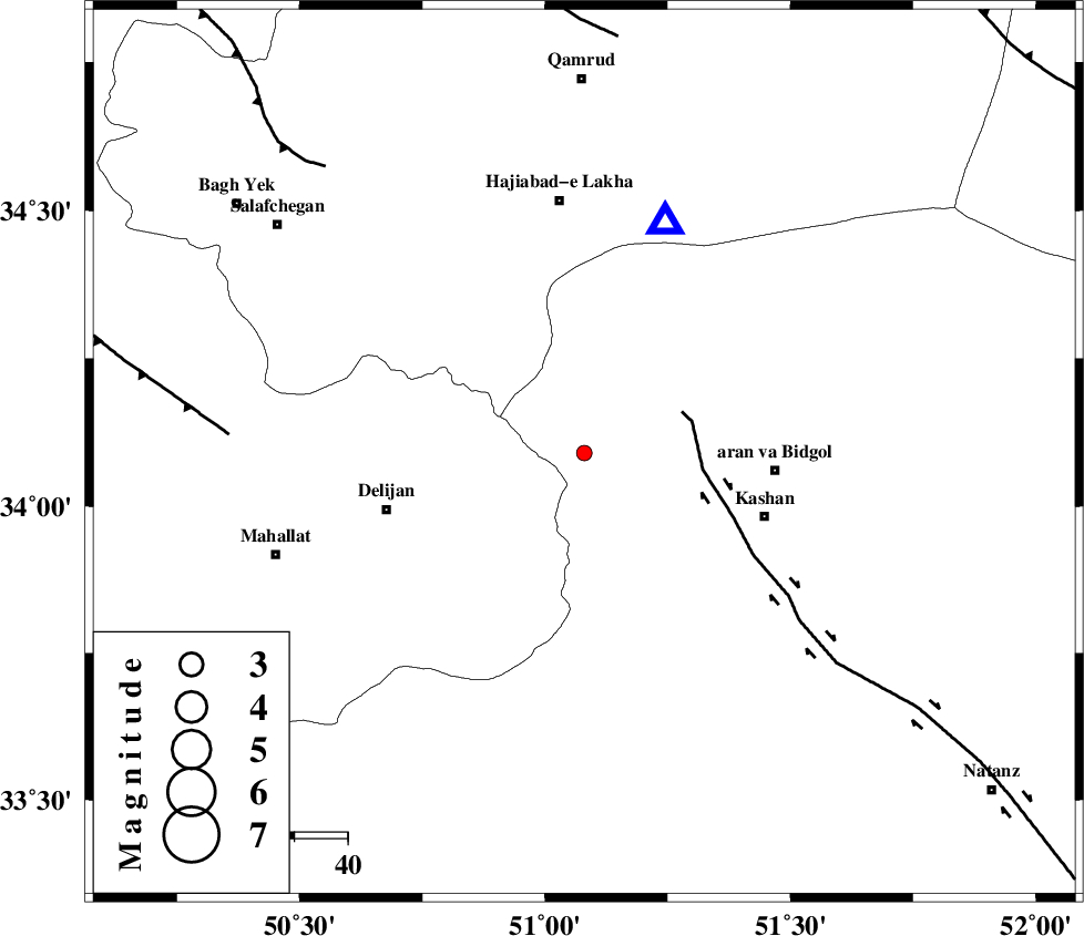
| Date & Time (UTC) | 2014-12-16 23:34:25.2 |
| Date & Time (Local) | 1393/9/26 03:04:25.2 |
| Location | Lat:34.09 Lon: 51.08 |
| Region | Esfahan Province, 36 km West of Aran va bidgol |
Nearest Cities |
|
| 3 km of Armak, Esfahan Province | |
| 13 km North East of Joshaq, Markazi Province | |
| 15 km North of Niyasar, Esfahan Province | |
| 16 km North West of Astarak, Esfahan Province | |
| 17 km South of Yahyaabad, Esfahan Province | |
| Depth | 15 km |
| Agency | |
Faults within 150 km: |
|
| KASHAN_F (Length: 44 km) , Distance to epicenter: 20 km | |
| ZEFREH_F (Length: 124 km) , Distance to epicenter: 51 km | |
| TAFRESH_F (Length: 117 km) , Distance to epicenter: 67 km | |
| Number of Phases | 3 |
| RMS | 0 |
| Number of Stations | 3 |
| Error in Latitude | >3.4 km |
| Error in Longitude | 3.7 km |
| Error in Depth | 0 km |
Download waveform in seisan format
to download seisan software Click here
to access information about IIEES stations Click here
Amplitude | ||||||||
| UID | Agency | Station | Component | Amplitude | Period | Arrival Time | Proccessing Time | Signal Clip |
| 94530 | IIEES | GHVR | E | 154.5 | 0.92 | 2014-12-16 23:34:41 | 2014-12-17 03:29:00 | n |
| 94531 | IIEES | GHVR | N | 139.8 | 0.2 | 2014-12-16 23:34:41 | 2014-12-17 03:29:00 | n |
Phase | ||||||||||||
| Agency | Station | Component | Phase Type | Phase Quality | First Motion | Observed Arrival Time | Time Residual | Loc. Flag | Input Weight | Distance | Azimuth | |
| IIEES | GHVR | Z | Pg | E | 2014-12-16 23:34:33 | 0.01 | y | 46.5 | 19 | |||
| IIEES | KHMZ | Z | Pg | E | 2014-12-16 23:34:43 | 0.01 | y | 110 | 250 | |||
| IIEES | ASAO | Z | Pg | E | 2014-12-16 23:34:43 | -0.01 | y | 110 | 298 | |||