
Magnitude |
:2.2 |
| Date & Time (UTC) | 2014-12-08 09:27:21.9 |
| Date & Time (Local) | 1393/9/17 12:57:21.9 |
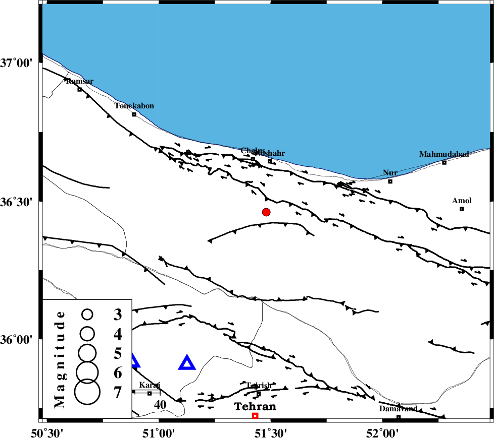
| Location | Lat:36.46 Lon: 51.48 |
| Region | Mazandaran Province, 21 km South of Nowshahr |
Nearest Cities |
|
| 12 km North West of Pul, Mazandaran Province | |
| 19 km North East of Marzanabad, Mazandaran Province | |
| 20 km East of Goyter, Mazandaran Province | |
| 20 km North East of Tavir, Mazandaran Province | |
| 21 km South of Nowshahr, Mazandaran Province | |
| Depth | 14 km |
| Agency | |
Faults within 150 km: |
|
| N_ALBORZ_F (Length: 360 km) , Distance to epicenter: 5 km | |
| KOJOOR (Length: 75 km) , Distance to epicenter: 8 km | |
| KHAZAR_F (Length: 523 km) , Distance to epicenter: 15 km | |
| Number of Phases | 8 |
| RMS | 0.1 |
| Number of Stations | 5 |
| Error in Latitude | >2.2 km |
| Error in Longitude | 2.1 km |
| Error in Depth | 4 km |
Download waveform in seisan format
to download seisan software Click here
to access information about IIEES stations Click here
Amplitude | ||||||||
| UID | Agency | Station | Component | Amplitude | Period | Arrival Time | Proccessing Time | Signal Clip |
| 94472 | IIEES | DAMV | E | 81.2 | 0.29 | 2014-12-08 09:27:53 | 2014-12-08 10:07:00 | n |
| 94473 | IIEES | GHVR | N | 16.8 | 0.57 | 2014-12-08 09:28:30 | 2014-12-08 10:07:00 | n |
Phase | ||||||||||||
| Agency | Station | Component | Phase Type | Phase Quality | First Motion | Observed Arrival Time | Time Residual | Loc. Flag | Input Weight | Distance | Azimuth | |
| IIEES | CHTH | Z | Pg | E | 2014-12-08 09:27:33 | -0.23 | y | 68.4 | 208 | |||
| IIEES | CHTH | N | Sg | E | 2014-12-08 09:27:42 | 0.07 | y | 68.4 | 208 | |||
| IIEES | DAMV | Z | Pg | E | 2014-12-08 09:27:39 | 0.05 | y | 102 | 154 | |||
| IIEES | DAMV | E | Sg | E | 2014-12-08 09:27:52 | -0.02 | y | 102 | 154 | |||
| IIEES | GHVR | Z | Pn | E | 2014-12-08 09:27:57 | 0 | y | 220 | 186 | |||
| IIEES | GHVR | E | Sg | E | 2014-12-08 09:28:24 | 0.01 | y | 220 | 186 | |||
| IIEES | ASAO | Z | Pn | E | 2014-12-08 09:28:00 | 0.11 | y | 249 | 212 | |||
| IIEES | ZNJK | Z | Pn | E | 2014-12-08 09:28:01 | 0.01 | y | 251 | 276 | |||