
Magnitude |
:2.1 |
| Date & Time (UTC) | 2014-11-19 08:06:48.8 |
| Date & Time (Local) | 1393/8/28 11:36:48.8 |
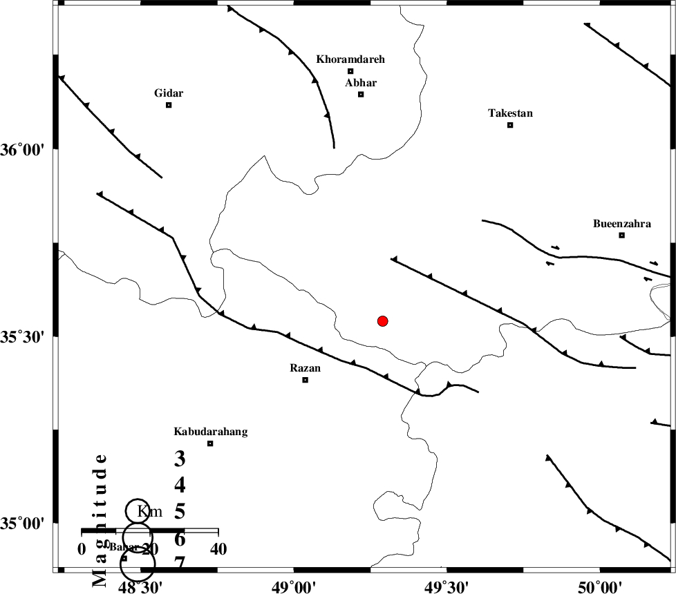
| Location | Lat:35.63 Lon: 49.23 |
| Region | Ghazvin Province, 32 km North-East of Razan |
Nearest Cities |
|
| 5 km North of Avaj, Ghazvin Province | |
| 15 km South of Ab-e garm, Ghazvin Province | |
| 22 km North West of Kolanjin, Ghazvin Province | |
| 28 km South West of Hoseynabad, Ghazvin Province | |
| 32 km North East of Razan, Hamedan Province | |
| Depth | 14 km |
| Agency | |
Faults within 150 km: |
|
| KUSHK_E_NOSRAT_F (Length: 230 km) , Distance to epicenter: 8 km | |
| IPAK_F (Length: 80 km) , Distance to epicenter: 40 km | |
| S_PARANDAK_F (Length: 116 km) , Distance to epicenter: 42 km | |
| Number of Phases | 5 |
| RMS | 0.1 |
| Number of Stations | 4 |
| Error in Latitude | >1.6 km |
| Error in Longitude | 1.6 km |
| Error in Depth | 5.8 km |
Download waveform in seisan format
to download seisan software Click here
to access information about IIEES stations Click here
Amplitude | ||||||||
| UID | Agency | Station | Component | Amplitude | Period | Arrival Time | Proccessing Time | Signal Clip |
| 94322 | IIEES | SNGE | N | 22.8 | 0.45 | 2014-11-19 08:07:41 | 2014-11-19 08:53:00 | n |
Phase | ||||||||||||
| Agency | Station | Component | Phase Type | Phase Quality | First Motion | Observed Arrival Time | Time Residual | Loc. Flag | Input Weight | Distance | Azimuth | |
| IIEES | ZNJK | Z | Pg | E | 2014-11-19 08:07:10 | 0.08 | y | 126 | 337 | |||
| IIEES | ZNJK | E | Sg | E | 2014-11-19 08:07:25 | 0 | y | 126 | 337 | |||
| IIEES | ASAO | Z | Pn | E | 2014-11-19 08:07:14 | 0.13 | y | 140 | 149 | |||
| IIEES | CHTH | Z | Pg | E | 2014-11-19 08:07:17 | -0.14 | y | 174 | 79 | |||
| IIEES | SNGE | N | Sg | E | 2014-11-19 08:07:40 | -0.07 | y | 181 | 251 | |||