
Magnitude |
:3.5 |
| Date & Time (UTC) | 2014-11-13 10:58:57.0 |
| Date & Time (Local) | 1393/8/22 14:28:57.0 |
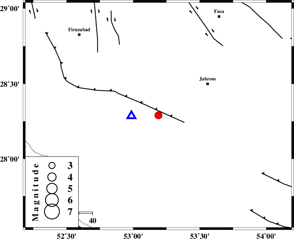
| Location | Lat:28.29 Lon: 53.19 |
| Region | Fars Province, 25 km South-East of Qir va Karzin |
Nearest Cities |
|
| 15 km North of Seyfabad, Fars Province | |
| 16 km West of Mobarakabad, Fars Province | |
| 18 km South East of Shahrak-e jonubi, Fars Province | |
| 22 km South of Fathabad, Fars Province | |
| 25 km South East of Qir va Karzin, Fars Province | |
| Depth | 18 km |
| Agency | |
Faults within 150 km: |
|
| QIR_F (Length: 130 km) , Distance to epicenter: 16 km | |
| SABZ_PUSHAN_F_Z2 (Length: 24 km) , Distance to epicenter: 60 km | |
| SABZ_PUSHAN_F_Z1 (Length: 69 km) , Distance to epicenter: 64 km | |
| Number of Phases | 8 |
| RMS | 0.1 |
| Number of Stations | 5 |
| Error in Latitude | >7.1 km |
| Error in Longitude | 2.4 km |
| Error in Depth | 5.6 km |
Download waveform in seisan format
to download seisan software Click here
to access information about IIEES stations Click here
Amplitude | ||||||||
| UID | Agency | Station | Component | Amplitude | Period | Arrival Time | Proccessing Time | Signal Clip |
| 94271 | IIEES | GHIR | E | 9336 | 0.46 | 2014-11-13 10:59:08 | 2014-11-13 11:23:00 | n |
Phase | ||||||||||||
| Agency | Station | Component | Phase Type | Phase Quality | First Motion | Observed Arrival Time | Time Residual | Loc. Flag | Input Weight | Distance | Azimuth | |
| IIEES | GHIR | Z | Pg | E | 2014-11-13 10:59:01 | 0.06 | y | 20 | 268 | |||
| IIEES | GHIR | E | Sg | E | 2014-11-13 10:59:05 | -0.03 | y | 20 | 268 | |||
| IIEES | AHRM | Z | Pg | E | 2014-11-13 10:59:28 | 0.13 | y | 196 | 289 | |||
| IIEES | AHRM | E | Sg | E | 2014-11-13 10:59:51 | -0.09 | y | 196 | 289 | |||
| IIEES | YZKH | Z | Pn | E | 2014-11-13 11:00:03 | -0.08 | y | 474 | 16 | |||
| IIEES | NASN | Z | Pn | E | 2014-11-13 11:00:06 | -0.15 | y | 501 | 356 | |||
| IIEES | NASN | N | S | E | 2014-11-13 11:00:58 | 0.16 | y | 501 | 356 | |||
| IIEES | TABS | Z | Pn | E | 2014-11-13 11:00:31 | -0.03 | y | 703 | 31 | |||